
 Belém
Maranguape
Paranaguá
Paranaguá
Monte Alegre
Alvorada de Minas
Bragança
Laguna
Ibiporã
Belém
Maranguape
Paranaguá
Paranaguá
Monte Alegre
Alvorada de Minas
Bragança
Laguna
Ibiporã
O Desbravador on the map, Chapecó, Brazil
Photo
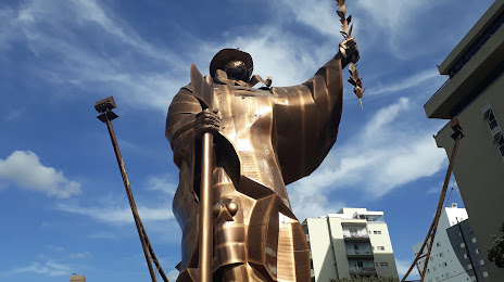
Where is located O Desbravador
O Desbravador — local attraction, which is located at Av. Getúlio Dorneles Vargas, s/n - Centro, Chapecó - SC, 89802-000, Brazil and belongs to the category — tourist attraction. Average visitor rating for this place — 4.6 (according to 189 ratings, information from open sources and relevant for 2022).
Exact location — O Desbravador, marked on the map with a red marker.
You can get directions to O Desbravador on the map from your location.
What else is interesting in Chapecó? You can see all the sights if you go to the city page.
Coordinates
O Desbravador, Brazil coordinates in decimal format: latitude — -27.105108735611527, longitude — -52.61433377549602. When converted to degrees, minutes, seconds O Desbravador has the following coordinates: -27°6′18.39 north latitude and -52°36′51.6 east longitude.
Nearby cities
The largest cities that are located nearby:
- Passo Fundo — 129 km
- Guarapuava — 221 km
- Lages — 237 km
- Cascavel — 252 km
- Foz do Iguaçu — 263 km
- Ciudad del Este
 (Paraguay) — 266 km
 - Caxias do Sul — 267 km
- Santa Cruz do Sul — 290 km
- Santa Maria — 308 km
- Novo Hamburgo — 320 km
- Posadas
 (Argentina) — 324 km
 - São Leopoldo — 325 km
- Canoas — 340 km
- Cachoeirinha — 347 km
- Blumenau — 350 km
- Gravataí — 351 km
- Porto Alegre — 351 km
- Guaíba — 355 km
- Jaraguá do Sul — 357 km