
 Belém
Maranguape
Paranaguá
Paranaguá
Monte Alegre
Alvorada de Minas
Bragança
Laguna
Ibiporã
Belém
Maranguape
Paranaguá
Paranaguá
Monte Alegre
Alvorada de Minas
Bragança
Laguna
Ibiporã
Chapeco National Forest on the map, Chapecó, Brazil
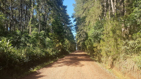
Photo
Where is located Chapeco National Forest
Chapeco National Forest — local attraction, which is located at Guatambu - State of Santa Catarina, 89817-000, Brazil and belongs to the category — national forest. Average visitor rating for this place — 4.4 (according to 195 ratings, information from open sources and relevant for 2022).
Exact location — Chapeco National Forest, marked on the map with a red marker.
You can get directions to Chapeco National Forest on the map from your location.
What else is interesting in Chapecó? You can see all the sights if you go to the city page.
Coordinates
Chapeco National Forest, Brazil coordinates in decimal format: latitude — -27.138422185522057, longitude — -52.69887748793925. When converted to degrees, minutes, seconds Chapeco National Forest has the following coordinates: -27°8′18.32 north latitude and -52°41′55.96 east longitude.
Nearby cities
The largest cities that are located nearby:
- Passo Fundo — 129 km
- Guarapuava — 221 km
- Lages — 237 km
- Cascavel — 252 km
- Foz do Iguaçu — 263 km
- Ciudad del Este
 (Paraguay) — 266 km
 - Caxias do Sul — 267 km
- Santa Cruz do Sul — 290 km
- Santa Maria — 308 km
- Novo Hamburgo — 320 km
- Posadas
 (Argentina) — 324 km
 - São Leopoldo — 325 km
- Canoas — 340 km
- Cachoeirinha — 347 km
- Blumenau — 350 km
- Gravataí — 351 km
- Porto Alegre — 351 km
- Guaíba — 355 km
- Jaraguá do Sul — 357 km