
 Belém
Maranguape
Paranaguá
Paranaguá
Monte Alegre
Alvorada de Minas
Bragança
Laguna
Ibiporã
Belém
Maranguape
Paranaguá
Paranaguá
Monte Alegre
Alvorada de Minas
Bragança
Laguna
Ibiporã
Fritz Plaumann State Park on the map, Concórdia, Brazil
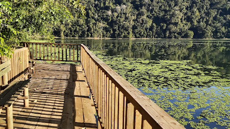
Photo
Where is located Fritz Plaumann State Park
Fritz Plaumann State Park — local attraction, which is located at Linha Sede Brum Interior, Concórdia - SC, 89700-000, Brazil and belongs to the category — state park. Average visitor rating for this place — 4.6 (according to 107 ratings, information from open sources and relevant for 2022).
Exact location — Fritz Plaumann State Park, marked on the map with a red marker.
You can get directions to Fritz Plaumann State Park on the map from your location.
What else is interesting in Concórdia? You can see all the sights if you go to the city page.
Coordinates
Fritz Plaumann State Park, Brazil coordinates in decimal format: latitude — -27.29424265458914, longitude — -52.10996147549202. When converted to degrees, minutes, seconds Fritz Plaumann State Park has the following coordinates: -27°17′39.27 north latitude and -52°6′35.86 east longitude.
Nearby cities
The largest cities that are located nearby:
- Chapecó — 60 km
- Passo Fundo — 119 km
- Lages — 178 km
- Guarapuava — 211 km
- Caxias do Sul — 228 km
- Santa Cruz do Sul — 278 km
- Novo Hamburgo — 285 km
- Cascavel — 290 km
- São Leopoldo — 291 km
- Blumenau — 293 km
- Criciúma — 303 km
- Jaraguá do Sul — 304 km
- Canoas — 307 km
- Cachoeirinha — 313 km
- Gravataí — 315 km
- Foz do Iguaçu — 318 km
- Araucária — 319 km
- Porto Alegre — 319 km
- Ciudad del Este
 (Paraguay) — 321 km