
 Maureville
Samoëns
Gréning
Toulouse
Volx
Goudet
Méhoncourt
Saint-Hymer
Pontcarré
Maureville
Samoëns
Gréning
Toulouse
Volx
Goudet
Méhoncourt
Saint-Hymer
Pontcarré
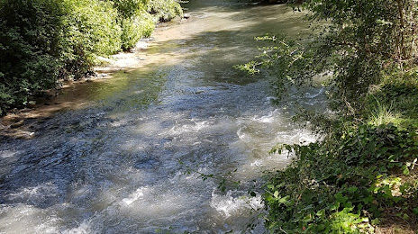
Touloubre (La Touloubre) on the map, Berre-l'Étang, France
Photo
Where is located Touloubre (La Touloubre)
Touloubre (La Touloubre) — local attraction, which is located at 60 km and belongs to the category — -. Average visitor rating for this place — 4.2 (according to 38 ratings, information from open sources and relevant for 2022).
Exact location — Touloubre (La Touloubre), marked on the map with a red marker.
You can get directions to Touloubre (La Touloubre) on the map from your location.
What else is interesting in Berre-l'Étang? You can see all the sights if you go to the city page.
Coordinates
Touloubre (La Touloubre), France coordinates in decimal format: latitude — 43.54290209468564, longitude — 5.045818624949021. When converted to degrees, minutes, seconds Touloubre (La Touloubre) has the following coordinates: 43°32′34.45 north latitude and 5°2′44.95 east longitude.
Nearby cities
The largest cities that are located nearby:
- Aix-en-Provence — 23 km
- Marseille — 26 km
- Toulon — 73 km
- Nimes — 76 km
- Montpellier — 104 km
- Nice — 169 km
- Grenoble — 194 km
- Perpignan — 204 km
- Saint-Étienne — 225 km
- Lyon — 254 km
- Villeurbanne — 255 km
- Turin
 (Italy) — 264 km
 - Toulouse — 298 km
- Clermont-Ferrand — 301 km
- Geneva
 (Switzerland) — 310 km
 - Mataró
 (Spain) — 311 km
 - Genoa (Italy) — 316 km
- Badalona (Spain) — 330 km
- Sabadell (Spain) — 331 km
Distance to the capital
Distance to the capital (Paris) is about — 626 km.