
 Maureville
Samoëns
Gréning
Toulouse
Volx
Goudet
Méhoncourt
Saint-Hymer
Pontcarré
Maureville
Samoëns
Gréning
Toulouse
Volx
Goudet
Méhoncourt
Saint-Hymer
Pontcarré
La Terre on the map, Croissy-sur-Seine, France
Photo
Where is located La Terre
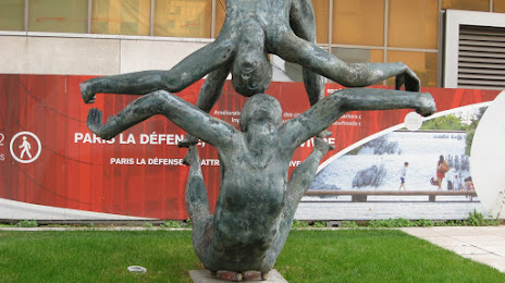
La Terre — local attraction, which is located at Entrepont Reflets, 92400 Courbevoie, France and belongs to the category — sculpture by louis derbré. Average visitor rating for this place — 5.0 (according to 2 ratings, information from open sources and relevant for 2022).
Exact location — La Terre, marked on the map with a red marker.
You can get directions to La Terre on the map from your location.
What else is interesting in Croissy-sur-Seine? You can see all the sights if you go to the city page.
Coordinates
La Terre, France coordinates in decimal format: latitude — 48.82364313026393, longitude — 2.332509198724328. When converted to degrees, minutes, seconds La Terre has the following coordinates: 48°49′25.12 north latitude and 2°19′57.03 east longitude.
Nearby cities
The largest cities that are located nearby:
- Boulogne-Billancourt — 8 km
- Rouen — 98 km
- Orléans — 109 km
- Amiens — 113 km
- Reims — 143 km
- Le Havre — 161 km
- Le Mans — 173 km
- Caen — 185 km
- Tours — 197 km
- Lille — 204 km
- Charleroi
 (Belgium) — 235 km
 - Eastbourne
 (United Kingdom) — 246 km
 - Angers — 255 km
- Namur (Belgium) — 260 km
- Brussels (Belgium) — 267 km
- Dijon — 277 km
- Metz — 293 km
- Rennes — 294 km
- Crawley (United Kingdom) — 295 km
Distance to the capital
Distance to the capital (Paris) is about — 4 km.