
 Belém
Maranguape
Paranaguá
Paranaguá
Monte Alegre
Alvorada de Minas
Bragança
Laguna
Ibiporã
Belém
Maranguape
Paranaguá
Paranaguá
Monte Alegre
Alvorada de Minas
Bragança
Laguna
Ibiporã
Parque Histórico General Bento Gonçalves on the map, Camaquã, Brazil
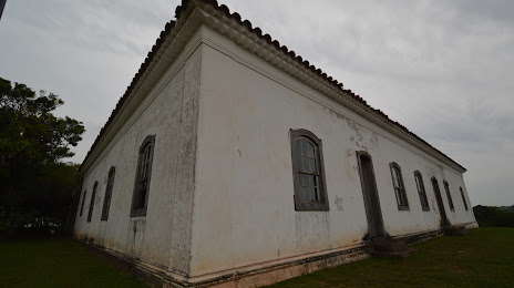
Photo
Where is located Parque Histórico General Bento Gonçalves
Parque Histórico General Bento Gonçalves — local attraction, which is located at Cordeiro, Cristal, Rio Grande do Sul - State of Rio Grande do Sul, 96195-000, Brazil and belongs to the category — museum. Average visitor rating for this place — 4.3 (according to 109 ratings, information from open sources and relevant for 2022).
Exact location — Parque Histórico General Bento Gonçalves, marked on the map with a red marker.
You can get directions to Parque Histórico General Bento Gonçalves on the map from your location.
What else is interesting in Camaquã? You can see all the sights if you go to the city page.
Coordinates
Parque Histórico General Bento Gonçalves, Brazil coordinates in decimal format: latitude — -30.98821276927927, longitude — -52.011751875407505. When converted to degrees, minutes, seconds Parque Histórico General Bento Gonçalves has the following coordinates: -30°59′17.57 north latitude and -52°0′42.31 east longitude.
Nearby cities
The largest cities that are located nearby:
- Guaíba — 94 km
- Porto Alegre — 106 km
- Pelotas — 113 km
- Viamão — 113 km
- Canoas — 119 km
- Cachoeirinha — 120 km
- Gravataí — 127 km
- Rio Grande — 134 km
- São Leopoldo — 136 km
- Santa Cruz do Sul — 138 km
- Novo Hamburgo — 144 km
- Caxias do Sul — 196 km
- Santa Maria — 232 km
- Passo Fundo — 292 km
- Criciúma — 337 km
- Lages — 365 km
- Chapecó — 422 km
- Palhoça — 469 km
- São José — 474 km