
 Maureville
Samoëns
Gréning
Toulouse
Volx
Goudet
Méhoncourt
Saint-Hymer
Pontcarré
Maureville
Samoëns
Gréning
Toulouse
Volx
Goudet
Méhoncourt
Saint-Hymer
Pontcarré
City/Town Hall Park on the map, Tremblay-en-France, France
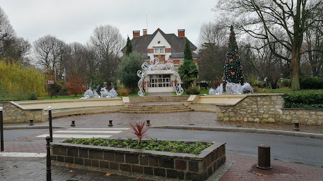
Photo
Where is located City/Town Hall Park
City/Town Hall Park — local attraction, which is located at 34 Av. Charles de Gaulle, 95700 Roissy-en-France, France and belongs to the category — park. Average visitor rating for this place — 4.3 (according to 183 ratings, information from open sources and relevant for 2022).
Exact location — City/Town Hall Park, marked on the map with a red marker.
You can get directions to City/Town Hall Park on the map from your location.
What else is interesting in Tremblay-en-France? You can see all the sights if you go to the city page.
Coordinates
City/Town Hall Park, France coordinates in decimal format: latitude — 48.91009509639951, longitude — 2.428417059273539. When converted to degrees, minutes, seconds City/Town Hall Park has the following coordinates: 48°54′36.34 north latitude and 2°25′42.3 east longitude.
Nearby cities
The largest cities that are located nearby:
- Boulogne-Billancourt — 28 km
- Amiens — 103 km
- Reims — 111 km
- Rouen — 117 km
- Orléans — 128 km
- Le Havre — 185 km
- Lille — 186 km
- Le Mans — 205 km
- Charleroi
 (Belgium) — 207 km
 - Caen — 213 km
- Tours — 224 km
- Namur (Belgium) — 231 km
- Brussels (Belgium) — 242 km
- Eastbourne
 (United Kingdom) — 253 km
 - Dijon — 261 km
- Metz — 262 km
- Nancy — 267 km
- Antwerp (Belgium) — 279 km
- Liège (Belgium) — 280 km
Distance to the capital
Distance to the capital (Paris) is about — 8 km.