
 Maureville
Samoëns
Gréning
Toulouse
Volx
Goudet
Méhoncourt
Saint-Hymer
Pontcarré
Maureville
Samoëns
Gréning
Toulouse
Volx
Goudet
Méhoncourt
Saint-Hymer
Pontcarré
Paris France Temple on the map, La Celle-Saint-Cloud, France
Photo
Where is located Paris France Temple
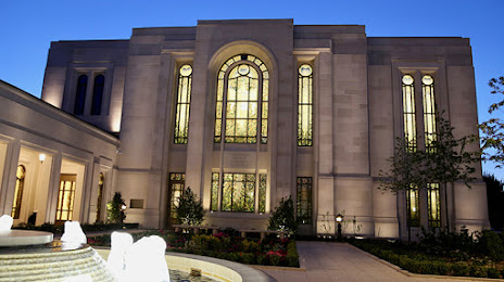
Paris France Temple — local attraction, which is located at 46 Bd Saint-Antoine, 78150 Le Chesnay-Rocquencourt, France and belongs to the category — church of jesus christ of latter-day saints. Average visitor rating for this place — 4.8 (according to 417 ratings, information from open sources and relevant for 2022).
Exact location — Paris France Temple, marked on the map with a red marker.
You can get directions to Paris France Temple on the map from your location.
What else is interesting in La Celle-Saint-Cloud? You can see all the sights if you go to the city page.
Coordinates
Paris France Temple, France coordinates in decimal format: latitude — 48.848592261784304, longitude — 2.2013064682733483. When converted to degrees, minutes, seconds Paris France Temple has the following coordinates: 48°50′54.93 north latitude and 2°12′4.7 east longitude.
Nearby cities
The largest cities that are located nearby:
- Boulogne-Billancourt — 8 km
- Rouen — 99 km
- Orléans — 106 km
- Amiens — 116 km
- Reims — 144 km
- Le Havre — 162 km
- Le Mans — 171 km
- Caen — 185 km
- Tours — 194 km
- Lille — 207 km
- Charleroi
 (Belgium) — 237 km
 - Eastbourne
 (United Kingdom) — 248 km
 - Angers — 252 km
- Namur (Belgium) — 263 km
- Brussels (Belgium) — 270 km
- Dijon — 276 km
- Rennes — 293 km
- Metz — 294 km
- Nancy — 296 km
Distance to the capital
Distance to the capital (Paris) is about — 11 km.