
 Maureville
Samoëns
Gréning
Toulouse
Volx
Goudet
Méhoncourt
Saint-Hymer
Pontcarré
Maureville
Samoëns
Gréning
Toulouse
Volx
Goudet
Méhoncourt
Saint-Hymer
Pontcarré
Parc de Noisiel on the map, Chennevières-sur-Marne, France
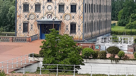
Photo
Where is located Parc de Noisiel
Parc de Noisiel — local attraction, which is located at 1 Cr du Château, 77186 Noisiel, France and belongs to the category — park. Average visitor rating for this place — 4.4 (according to 2533 ratings, information from open sources and relevant for 2022).
Exact location — Parc de Noisiel, marked on the map with a red marker.
You can get directions to Parc de Noisiel on the map from your location.
What else is interesting in Chennevières-sur-Marne? You can see all the sights if you go to the city page.
Coordinates
Parc de Noisiel, France coordinates in decimal format: latitude — 48.79450472945596, longitude — 2.5432169782390046. When converted to degrees, minutes, seconds Parc de Noisiel has the following coordinates: 48°47′40.22 north latitude and 2°32′35.58 east longitude.
Nearby cities
The largest cities that are located nearby:
- Boulogne-Billancourt — 22 km
- Orléans — 109 km
- Reims — 119 km
- Amiens — 123 km
- Rouen — 126 km
- Le Havre — 191 km
- Le Mans — 194 km
- Lille — 206 km
- Tours — 208 km
- Caen — 214 km
- Charleroi
 (Belgium) — 224 km
 - Namur (Belgium) — 247 km
- Dijon — 249 km
- Brussels (Belgium) — 260 km
- Metz — 266 km
- Nancy — 267 km
- Eastbourne
 (United Kingdom) — 269 km
 - Angers — 274 km
- Liège (Belgium) — 295 km
Distance to the capital
Distance to the capital (Paris) is about — 16 km.