
 Maureville
Samoëns
Gréning
Toulouse
Volx
Goudet
Méhoncourt
Saint-Hymer
Pontcarré
Maureville
Samoëns
Gréning
Toulouse
Volx
Goudet
Méhoncourt
Saint-Hymer
Pontcarré
Lac Bleu on the map, Ambérieu-en-Bugey, France
Photo
Where is located Lac Bleu
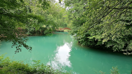
Lac Bleu — local attraction, which is located at Rue de Vareilles, 01500 Ambérieu-en-Bugey, France and belongs to the category — tourist attraction. Average visitor rating for this place — 4.2 (according to 413 ratings, information from open sources and relevant for 2022).
Exact location — Lac Bleu, marked on the map with a red marker.
You can get directions to Lac Bleu on the map from your location.
What else is interesting in Ambérieu-en-Bugey? You can see all the sights if you go to the city page.
Coordinates
Lac Bleu, France coordinates in decimal format: latitude — 45.95687346059406, longitude — 5.369647552822012. When converted to degrees, minutes, seconds Lac Bleu has the following coordinates: 45°57′24.74 north latitude and 5°22′10.73 east longitude.
Nearby cities
The largest cities that are located nearby:
- Villeurbanne — 42 km
- Lyon — 46 km
- Geneva
 (Switzerland) — 66 km
 - Grenoble — 90 km
- Saint-Étienne — 95 km
- Lausanne (Switzerland) — 115 km
- Besançon — 150 km
- Dijon — 153 km
- Clermont-Ferrand — 176 km
- Bern (Switzerland) — 192 km
- Turin
 (Italy) — 207 km
 - Basel (Switzerland) — 244 km
- Mulhouse — 247 km
- Nimes — 248 km
- Novara (Italy) — 259 km
- Aix-en-Provence — 269 km
- Zurich (Switzerland) — 285 km
- Montpellier — 285 km
- Freiburg
 (Germany) — 291 km
Distance to the capital
Distance to the capital (Paris) is about — 394 km.