
 Bel-Ha
San Jose El Alto
El Porvenir
Nueva Palestina
Santa Lucía
Chemax
La Morita
Temoac
Zacualpan
Bel-Ha
San Jose El Alto
El Porvenir
Nueva Palestina
Santa Lucía
Chemax
La Morita
Temoac
Zacualpan
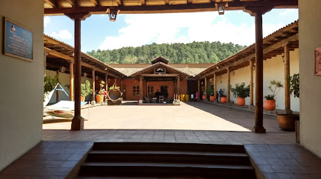
Museo Nacional del Cobre on the map, Santa Clara del Cobre, Mexico
Photo
Where is located Museo Nacional del Cobre
Museo Nacional del Cobre — local attraction, which is located at Avenida, Avineda Generalisimo Morelos Pte. 263, Centro, 61800 Santa Clara del Cobre, Mich., Mexico and belongs to the category — museum. Average visitor rating for this place — 4.6 (according to 2722 ratings, information from open sources and relevant for 2022).
Exact location — Museo Nacional del Cobre, marked on the map with a red marker.
You can get directions to Museo Nacional del Cobre on the map from your location.
What else is interesting in Santa Clara del Cobre? You can see all the sights if you go to the city page.
Coordinates
Museo Nacional del Cobre, Mexico coordinates in decimal format: latitude — 19.398360120994425, longitude — -101.6421725473844. When converted to degrees, minutes, seconds Museo Nacional del Cobre has the following coordinates: 19°23′54.1 north latitude and -101°38′31.82 east longitude.
Nearby cities
The largest cities that are located nearby:
- Uruapan — 42 km
- Morelia — 57 km
- Zamora — 93 km
- Salamanca — 136 km
- Irapuato — 144 km
- Celaya — 151 km
- Santiago de Querétaro — 184 km
- León — 190 km
- San Juan del Río — 203 km
- Toluca — 208 km
- Tonalá — 213 km
- Metepec — 214 km
- Colima — 218 km
- Tlaquepaque — 220 km
- Guadalajara — 225 km
- Zapopan — 231 km
- Ciudad López Mateos — 248 km
- Iguala — 250 km
- Cuautitlán Izcalli — 250 km
Distance to the capital
Distance to the capital (Mexico City) is about — 263 km.