
 Józefów nad Wisłą
Gorzyce Wielkie
Rogówek
Sromowce Niżne
Wyszków County
Kruszewo
Jantar
Sady Górne
Nagoszewo
Józefów nad Wisłą
Gorzyce Wielkie
Rogówek
Sromowce Niżne
Wyszków County
Kruszewo
Jantar
Sady Górne
Nagoszewo
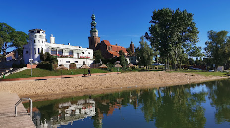
Plaża miejska „Ustronie” w Chełmży on the map, Chełmża, Poland
Photo
Where is located Plaża miejska „Ustronie” w Chełmży
Plaża miejska „Ustronie” w Chełmży — local attraction, which is located at no data and belongs to the category — -. Average visitor rating for this place — 4.4 (according to 320 ratings, information from open sources and relevant for 2022).
Exact location — Plaża miejska „Ustronie” w Chełmży, marked on the map with a red marker.
You can get directions to Plaża miejska „Ustronie” w Chełmży on the map from your location.
What else is interesting in Chełmża? You can see all the sights if you go to the city page.
Coordinates
Plaża miejska „Ustronie” w Chełmży, Poland coordinates in decimal format: latitude — 53.18479421932451, longitude — 18.611869713031147. When converted to degrees, minutes, seconds Plaża miejska „Ustronie” w Chełmży has the following coordinates: 53°11′5.26 north latitude and 18°36′42.73 east longitude.
Nearby cities
The largest cities that are located nearby:
- Torun — 19 km
- Bydgoszcz — 40 km
- Wloclawek — 67 km
- Plock — 102 km
- Elblag — 119 km
- Gdańsk — 129 km
- Olsztyn — 139 km
- Poznań — 142 km
- Gdynia — 148 km
- Kalisz — 161 km
- Łódź — 168 km
- Koszalin — 193 km
- Kaliningrad
 (Russia) — 209 km
 - Gorzów Wielkopolski — 231 km
- Zielona Gora — 252 km
- Wrocław — 254 km
- Radom — 264 km
- Częstochowa — 265 km
- Szczecin — 268 km
Distance to the capital
Distance to the capital (Warsaw) is about — 194 km.