
 Gilserberg
Berlin
Bordesholm
Bechtolsheim
Aub
Triptis
Heppenheim
Biblis
Angermünde
Gilserberg
Berlin
Bordesholm
Bechtolsheim
Aub
Triptis
Heppenheim
Biblis
Angermünde
Feuerwehrmuseum Kirchlengern-Häver on the map, Hüllhorst, Germany
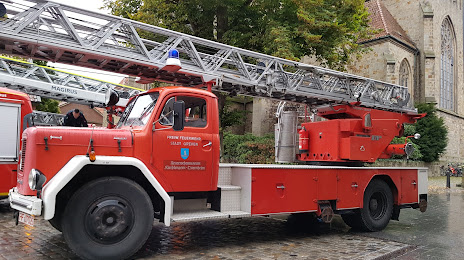
Photo
Where is located Feuerwehrmuseum Kirchlengern-Häver
Feuerwehrmuseum Kirchlengern-Häver — local attraction, which is located at Häverstraße 188, 32278 Kirchlengern, Germany and belongs to the category — museum. Average visitor rating for this place — 4.6 (according to 36 ratings, information from open sources and relevant for 2022).
Exact location — Feuerwehrmuseum Kirchlengern-Häver, marked on the map with a red marker.
You can get directions to Feuerwehrmuseum Kirchlengern-Häver on the map from your location.
What else is interesting in Hüllhorst? You can see all the sights if you go to the city page.
Coordinates
Feuerwehrmuseum Kirchlengern-Häver, Germany coordinates in decimal format: latitude — 52.231405609678966, longitude — 8.66838042534614. When converted to degrees, minutes, seconds Feuerwehrmuseum Kirchlengern-Häver has the following coordinates: 52°13′53.06 north latitude and 8°40′6.17 east longitude.
Nearby cities
The largest cities that are located nearby:
- Bielefeld — 28 km
- Osnabrück — 42 km
- Paderborn — 61 km
- Hanover — 72 km
- Münster — 79 km
- Hildesheim — 88 km
- Hamm — 88 km
- Bremen — 90 km
- Salzgitter — 113 km
- Göttingen — 117 km
- Dortmund — 118 km
- Kassel — 120 km
- Enschede
 (Netherlands) — 121 km
 - Recklinghausen — 125 km
- Brunswick — 125 km
- Witten — 129 km
- Herne — 130 km
- Hagen — 130 km
- Emmen (Netherlands) — 132 km
Distance to the capital
Distance to the capital (Berlin) is about — 323 km.