
 Puerto de la Duquesa
La Serna de Iguña
Pumalverde
Puentenansa
La Iglesia
Casar de Periedo
Fuengirola
Renedo de Piélagos
Villabanez
Puerto de la Duquesa
La Serna de Iguña
Pumalverde
Puentenansa
La Iglesia
Casar de Periedo
Fuengirola
Renedo de Piélagos
Villabanez
Montaña Virgen del Rosario Park on the map, Albatera, Spain
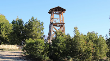
Photo
Where is located Montaña Virgen del Rosario Park
Montaña Virgen del Rosario Park — local attraction, which is located at Unnamed Road, 03340 Albatera, Alicante, Spain and belongs to the category — park. Average visitor rating for this place — 4.1 (according to 172 ratings, information from open sources and relevant for 2022).
Exact location — Montaña Virgen del Rosario Park, marked on the map with a red marker.
You can get directions to Montaña Virgen del Rosario Park on the map from your location.
What else is interesting in Albatera? You can see all the sights if you go to the city page.
Coordinates
Montaña Virgen del Rosario Park, Spain coordinates in decimal format: latitude — 38.23516125703433, longitude — -0.8829589751196196. When converted to degrees, minutes, seconds Montaña Virgen del Rosario Park has the following coordinates: 38°14′6.58 north latitude and -0°52′58.65 east longitude.
Nearby cities
The largest cities that are located nearby:
- Murcia — 31 km
- Cartagena — 62 km
- Albacete — 124 km
- Valencia — 149 km
- Almería — 205 km
- Jaén — 258 km
- Granada — 265 km
- Oran
 (Algeria) — 275 km
 - Chlef (Algeria) — 297 km
- Relizane (Algeria) — 299 km
- Alcala de Henares — 330 km
- Sidi Bel Abbes (Algeria) — 330 km
- Torrejón de Ardoz — 334 km
- Getafe — 337 km
- Palma — 337 km
- Fuenlabrada — 340 km
- Leganés — 341 km
- Córdoba — 343 km
- Alcorcón — 346 km
Distance to the capital
Distance to the capital (Madrid) is about — 343 km.