
 Puerto de la Duquesa
La Serna de Iguña
Pumalverde
Puentenansa
La Iglesia
Casar de Periedo
Fuengirola
Renedo de Piélagos
Villabanez
Puerto de la Duquesa
La Serna de Iguña
Pumalverde
Puentenansa
La Iglesia
Casar de Periedo
Fuengirola
Renedo de Piélagos
Villabanez
Castillo Callosa de Segura on the map, Orihuela, Spain
Photo
Where is located Castillo Callosa de Segura
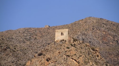
Castillo Callosa de Segura — local attraction, which is located at 29,, Grupo las Camineras, 27, 03360 Callosa de Segura, Alicante, Spain and belongs to the category — historical landmark. Average visitor rating for this place — 4.3 (according to 3 ratings, information from open sources and relevant for 2022).
Exact location — Castillo Callosa de Segura, marked on the map with a red marker.
You can get directions to Castillo Callosa de Segura on the map from your location.
What else is interesting in Orihuela? You can see all the sights if you go to the city page.
Coordinates
Castillo Callosa de Segura, Spain coordinates in decimal format: latitude — 38.11978409696174, longitude — -0.8834275751229549. When converted to degrees, minutes, seconds Castillo Callosa de Segura has the following coordinates: 38°7′11.22 north latitude and -0°53′0.34 east longitude.
Nearby cities
The largest cities that are located nearby:
- Murcia — 19 km
- Cartagena — 51 km
- Albacete — 127 km
- Valencia — 161 km
- Almería — 193 km
- Jaén — 250 km
- Granada — 254 km
- Oran
 (Algeria) — 266 km
 - Relizane (Algeria) — 293 km
- Chlef (Algeria) — 294 km
- Sidi Bel Abbes (Algeria) — 320 km
- Alcala de Henares — 334 km
- Córdoba — 335 km
- Torrejón de Ardoz — 338 km
- Getafe — 340 km
- Fuenlabrada — 343 km
- Málaga — 343 km
- Leganés — 344 km
- Palma — 348 km
Distance to the capital
Distance to the capital (Madrid) is about — 352 km.