
 Puerto de la Duquesa
La Serna de Iguña
Pumalverde
Puentenansa
La Iglesia
Casar de Periedo
Fuengirola
Renedo de Piélagos
Villabanez
Puerto de la Duquesa
La Serna de Iguña
Pumalverde
Puentenansa
La Iglesia
Casar de Periedo
Fuengirola
Renedo de Piélagos
Villabanez
Pasico Ucenda on the map, Bullas, Spain
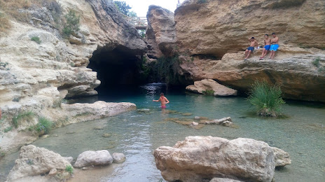
Photo
Where is located Pasico Ucenda
Pasico Ucenda — local attraction, which is located at Diseminado Sendero Fuente Mula, 30189 Bullas, Murcia, Spain and belongs to the category — tourist attraction. Average visitor rating for this place — 4.3 (according to 114 ratings, information from open sources and relevant for 2022).
Exact location — Pasico Ucenda, marked on the map with a red marker.
You can get directions to Pasico Ucenda on the map from your location.
What else is interesting in Bullas? You can see all the sights if you go to the city page.
Coordinates
Pasico Ucenda, Spain coordinates in decimal format: latitude — 38.023031046704816, longitude — -1.6837496751257806. When converted to degrees, minutes, seconds Pasico Ucenda has the following coordinates: 38°1′22.91 north latitude and -1°41′1.5 east longitude.
Nearby cities
The largest cities that are located nearby:
- Murcia — 48 km
- Cartagena — 75 km
- Albacete — 106 km
- Almería — 151 km
- Jaén — 187 km
- Valencia — 193 km
- Granada — 195 km
- Córdoba — 272 km
- Oran
 (Algeria) — 276 km
 - Málaga — 284 km
- Getafe — 305 km
- Alcala de Henares — 305 km
- Fuenlabrada — 307 km
- Torrejón de Ardoz — 307 km
- Leganés — 309 km
- Móstoles — 313 km
- Alcorcón — 313 km
- Alcobendas — 321 km
- Relizane (Algeria) — 324 km
Distance to the capital
Distance to the capital (Madrid) is about — 318 km.