
 Puerto de la Duquesa
La Serna de Iguña
Pumalverde
Puentenansa
La Iglesia
Casar de Periedo
Fuengirola
Renedo de Piélagos
Villabanez
Puerto de la Duquesa
La Serna de Iguña
Pumalverde
Puentenansa
La Iglesia
Casar de Periedo
Fuengirola
Renedo de Piélagos
Villabanez
Parque de la Muela on the map, El Viso del Alcor, Spain
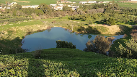
Photo
Where is located Parque de la Muela
Parque de la Muela — local attraction, which is located at C. Arroyo, 16, 41520 El Viso del Alcor, Sevilla, Spain and belongs to the category — nature preserve. Average visitor rating for this place — 4.2 (according to 118 ratings, information from open sources and relevant for 2022).
Exact location — Parque de la Muela, marked on the map with a red marker.
You can get directions to Parque de la Muela on the map from your location.
What else is interesting in El Viso del Alcor? You can see all the sights if you go to the city page.
Coordinates
Parque de la Muela, Spain coordinates in decimal format: latitude — 37.38259551678838, longitude — -5.720537275144173. When converted to degrees, minutes, seconds Parque de la Muela has the following coordinates: 37°22′57.34 north latitude and -5°43′13.93 east longitude.
Nearby cities
The largest cities that are located nearby:
- Dos Hermanas — 21 km
- Jerez — 86 km
- Córdoba — 99 km
- Cádiz — 108 km
- Huelva — 109 km
- Marbella — 122 km
- Málaga — 135 km
- Algeciras — 140 km
- Jaén — 175 km
- Tangier
 (Morocco) — 180 km
 - Granada — 188 km
- Badajoz — 197 km
- Tetouan (Morocco) — 204 km
- Almería — 295 km
- Lisbon
 (Portugal) — 330 km
 - Taounate (Morocco) — 330 km
- Amadora (Portugal) — 338 km
- Queluz (Portugal) — 340 km
- Nador (Morocco) — 352 km
Distance to the capital
Distance to the capital (Madrid) is about — 380 km.