
 Gilserberg
Berlin
Bordesholm
Bechtolsheim
Aub
Triptis
Heppenheim
Biblis
Angermünde
Gilserberg
Berlin
Bordesholm
Bechtolsheim
Aub
Triptis
Heppenheim
Biblis
Angermünde
Brodtener Steilküste on the map, Ratekau, Germany
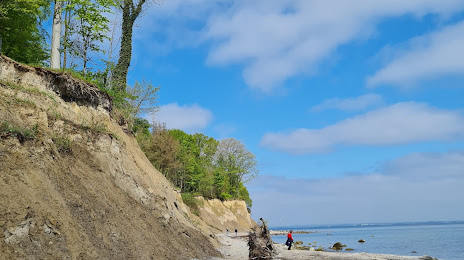
Photo
Where is located Brodtener Steilküste
Brodtener Steilküste — local attraction, which is located at Brodtener Str., 23570 Lübeck, Germany and belongs to the category — scenic spot. Average visitor rating for this place — 4.7 (according to 562 ratings, information from open sources and relevant for 2022).
Exact location — Brodtener Steilküste, marked on the map with a red marker.
You can get directions to Brodtener Steilküste on the map from your location.
What else is interesting in Ratekau? You can see all the sights if you go to the city page.
Coordinates
Brodtener Steilküste, Germany coordinates in decimal format: latitude — 53.99164019629867, longitude — 10.867123725412345. When converted to degrees, minutes, seconds Brodtener Steilküste has the following coordinates: 53°59′29.9 north latitude and 10°52′1.65 east longitude.
Nearby cities
The largest cities that are located nearby:
- Kiel — 57 km
- Rostock — 90 km
- Bremerhaven — 148 km
- Bremen — 160 km
- Odense
 (Denmark) — 162 km
 - Wolfsburg — 168 km
- Brunswick — 186 km
- Hanover — 186 km
- Salzgitter — 200 km
- Hildesheim — 205 km
- Magdeburg — 211 km
- Copenhagen (Denmark) — 223 km
- Malmö
 (Sweden) — 232 km
 - Potsdam — 233 km
- Berlin — 240 km
- Aarhus (Denmark) — 247 km
- Szczecin
 (Poland) — 258 km
 - Osnabrück — 259 km
- Bielefeld — 259 km
Distance to the capital
Distance to the capital (Berlin) is about — 235 km.