
 Puerto de la Duquesa
La Serna de Iguña
Pumalverde
Puentenansa
La Iglesia
Casar de Periedo
Fuengirola
Renedo de Piélagos
Villabanez
Puerto de la Duquesa
La Serna de Iguña
Pumalverde
Puentenansa
La Iglesia
Casar de Periedo
Fuengirola
Renedo de Piélagos
Villabanez
Cañada de los Pájaros on the map, Coria del Río, Spain
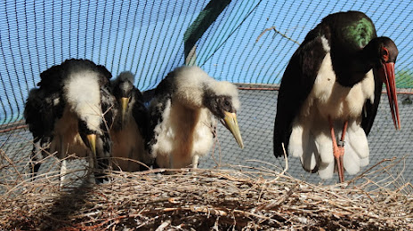
Photo
Where is located Cañada de los Pájaros
Cañada de los Pájaros — local attraction, which is located at Carretera de la Puebla del Río - Isla Mayor, km 8, 41130 La Puebla del Río, Sevilla, Sevilla, Spain and belongs to the category — nature preserve. Average visitor rating for this place — 4.4 (according to 642 ratings, information from open sources and relevant for 2022).
Exact location — Cañada de los Pájaros, marked on the map with a red marker.
You can get directions to Cañada de los Pájaros on the map from your location.
What else is interesting in Coria del Río? You can see all the sights if you go to the city page.
Coordinates
Cañada de los Pájaros, Spain coordinates in decimal format: latitude — 37.2386945433182, longitude — -6.131550375148271. When converted to degrees, minutes, seconds Cañada de los Pájaros has the following coordinates: 37°14′19.3 north latitude and -6°7′53.58 east longitude.
Nearby cities
The largest cities that are located nearby:
- Dos Hermanas — 11 km
- Jerez — 67 km
- Huelva — 78 km
- Cádiz — 87 km
- Córdoba — 129 km
- Marbella — 135 km
- Algeciras — 138 km
- Málaga — 155 km
- Tangier
 (Morocco) — 170 km
 - Badajoz — 193 km
- Tetouan (Morocco) — 200 km
- Jaén — 206 km
- Granada — 217 km
- Lisbon
 (Portugal) — 310 km
 - Amadora (Portugal) — 318 km
- Queluz (Portugal) — 321 km
- Almería — 322 km
- Taounate (Morocco) — 330 km
- Kenitra (Morocco) — 339 km
Distance to the capital
Distance to the capital (Madrid) is about — 411 km.