
 Gilserberg
Berlin
Bordesholm
Bechtolsheim
Aub
Triptis
Heppenheim
Biblis
Angermünde
Gilserberg
Berlin
Bordesholm
Bechtolsheim
Aub
Triptis
Heppenheim
Biblis
Angermünde
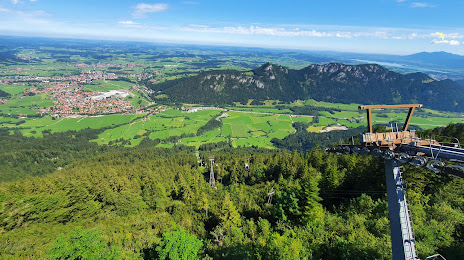
Breitenberg - Hochalpe - Pfronten on the map, Füssen, Germany
Photo
Where is located Breitenberg - Hochalpe - Pfronten
Breitenberg - Hochalpe - Pfronten — local attraction, which is located at Tiroler Str. 176, 87459 Pfronten, Germany and belongs to the category — ski resort. Average visitor rating for this place — 5.0 (according to 5 ratings, information from open sources and relevant for 2022).
Exact location — Breitenberg - Hochalpe - Pfronten, marked on the map with a red marker.
You can get directions to Breitenberg - Hochalpe - Pfronten on the map from your location.
What else is interesting in Füssen? You can see all the sights if you go to the city page.
Coordinates
Breitenberg - Hochalpe - Pfronten, Germany coordinates in decimal format: latitude — 47.56496630223999, longitude — 10.57527332517847. When converted to degrees, minutes, seconds Breitenberg - Hochalpe - Pfronten has the following coordinates: 47°33′53.88 north latitude and 10°34′30.98 east longitude.
Nearby cities
The largest cities that are located nearby:
- Innsbruck
 (Austria) — 62 km
 - Augsburg — 90 km
- Munich — 90 km
- Ulm — 106 km
- Ingolstadt — 143 km
- Reutlingen — 151 km
- Zurich
 (Switzerland) — 163 km
 - Trento
 (Italy) — 169 km
 - Stuttgart — 173 km
- Salzburg (Austria) — 177 km
- Regensburg — 189 km
- Heilbronn — 205 km
- Pforzheim — 207 km
- Nuremberg — 210 km
- Fürth — 212 km
- Freiburg — 217 km
- Bergamo (Italy) — 221 km
- Erlangen — 224 km
- Brescia (Italy) — 227 km
Distance to the capital
Distance to the capital (Berlin) is about — 587 km.