
 Józefów nad Wisłą
Gorzyce Wielkie
Rogówek
Sromowce Niżne
Wyszków County
Kruszewo
Jantar
Sady Górne
Nagoszewo
Józefów nad Wisłą
Gorzyce Wielkie
Rogówek
Sromowce Niżne
Wyszków County
Kruszewo
Jantar
Sady Górne
Nagoszewo
Pijalnia Główna w Krynicy Zdroju on the map, Krynica, Poland
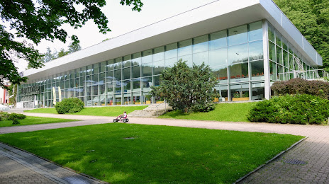
Photo
Where is located Pijalnia Główna w Krynicy Zdroju
Pijalnia Główna w Krynicy Zdroju — local attraction, which is located at aleja Nowotarskiego 9/4, 33-380 Krynica-Zdrój, Poland and belongs to the category — tourist attraction. Average visitor rating for this place — 4.4 (according to 5763 ratings, information from open sources and relevant for 2022).
Exact location — Pijalnia Główna w Krynicy Zdroju, marked on the map with a red marker.
You can get directions to Pijalnia Główna w Krynicy Zdroju on the map from your location.
What else is interesting in Krynica? You can see all the sights if you go to the city page.
Coordinates
Pijalnia Główna w Krynicy Zdroju, Poland coordinates in decimal format: latitude — 49.416863570922814, longitude — 20.957133625243657. When converted to degrees, minutes, seconds Pijalnia Główna w Krynicy Zdroju has the following coordinates: 49°25′0.71 north latitude and 20°57′25.68 east longitude.
Nearby cities
The largest cities that are located nearby:
- Tarnow — 65 km
- Košice
 (Slovakia) — 80 km
 - Rzeszow — 101 km
- Kraków — 101 km
- Uzhhorod
 (Ukraine) — 131 km
 - Bielsko-Biala — 143 km
- Miskolc
 (Hungary) — 147 km
 - Dabrowa Gornicza — 159 km
- Kielce — 161 km
- Sosnowiec — 162 km
- Katowice — 166 km
- Chorzow — 172 km
- Nyíregyháza (Hungary) — 172 km
- Ruda Slaska — 175 km
- Bytom — 177 km
- Zabrze — 183 km
- Rybnik — 187 km
- Gliwice — 188 km
- Ostrava
 (Czech Republic) — 197 km
Distance to the capital
Distance to the capital (Warsaw) is about — 313 km.