
 Gilserberg
Berlin
Bordesholm
Bechtolsheim
Aub
Triptis
Heppenheim
Biblis
Angermünde
Gilserberg
Berlin
Bordesholm
Bechtolsheim
Aub
Triptis
Heppenheim
Biblis
Angermünde
Naherholungsgebiet Wurmtal on the map, Übach-Palenberg, Germany
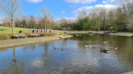
Photo
Where is located Naherholungsgebiet Wurmtal
Naherholungsgebiet Wurmtal — local attraction, which is located at 52531 Übach-Palenberg, Germany and belongs to the category — nature preserve. Average visitor rating for this place — 4.3 (according to 960 ratings, information from open sources and relevant for 2022).
Exact location — Naherholungsgebiet Wurmtal, marked on the map with a red marker.
You can get directions to Naherholungsgebiet Wurmtal on the map from your location.
What else is interesting in Übach-Palenberg? You can see all the sights if you go to the city page.
Coordinates
Naherholungsgebiet Wurmtal, Germany coordinates in decimal format: latitude — 50.93099125094753, longitude — 6.094320725298285. When converted to degrees, minutes, seconds Naherholungsgebiet Wurmtal has the following coordinates: 50°55′51.57 north latitude and 6°5′39.55 east longitude.
Nearby cities
The largest cities that are located nearby:
- Aachen — 16 km
- Maastricht
 (Netherlands) — 31 km
 - Mönchengladbach — 37 km
- Liège
 (Belgium) — 49 km
 - Neuss — 50 km
- Krefeld — 56 km
- Düsseldorf — 57 km
- Cologne — 59 km
- Moers — 69 km
- Bergisch Gladbach — 71 km
- Bonn — 71 km
- Duisburg — 72 km
- Solingen — 72 km
- Eindhoven (Netherlands) — 73 km
- Mülheim — 76 km
- Remscheid — 80 km
- Wuppertal — 81 km
- Oberhausen — 82 km
- Essen — 85 km
Distance to the capital
Distance to the capital (Berlin) is about — 534 km.