
 Puerto de la Duquesa
La Serna de Iguña
Pumalverde
Puentenansa
La Iglesia
Casar de Periedo
Fuengirola
Renedo de Piélagos
Villabanez
Puerto de la Duquesa
La Serna de Iguña
Pumalverde
Puentenansa
La Iglesia
Casar de Periedo
Fuengirola
Renedo de Piélagos
Villabanez
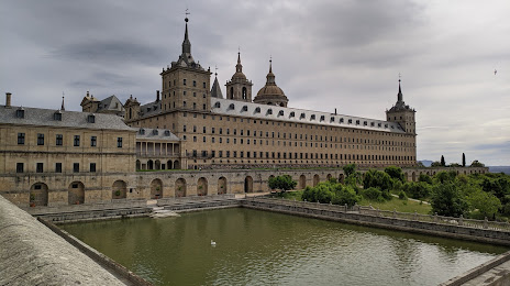
Felipe II Park (Parque Felipe II) on the map, San Lorenzo de El Escorial, Spain
Photo
Where is located Felipe II Park (Parque Felipe II)
Felipe II Park (Parque Felipe II) — local attraction, which is located at C. Infantes, 11, 28200 San Lorenzo de El Escorial, Madrid, Spain and belongs to the category — park. Average visitor rating for this place — 4.3 (according to 813 ratings, information from open sources and relevant for 2022).
Exact location — Felipe II Park (Parque Felipe II), marked on the map with a red marker.
You can get directions to Felipe II Park (Parque Felipe II) on the map from your location.
What else is interesting in San Lorenzo de El Escorial? You can see all the sights if you go to the city page.
Coordinates
Felipe II Park (Parque Felipe II), Spain coordinates in decimal format: latitude — 40.59125601712324, longitude — -4.142901175049338. When converted to degrees, minutes, seconds Felipe II Park (Parque Felipe II) has the following coordinates: 40°35′28.52 north latitude and -4°8′34.44 east longitude.
Nearby cities
The largest cities that are located nearby:
- Móstoles — 38 km
- Alcorcón — 38 km
- Leganés — 43 km
- Alcobendas — 43 km
- Fuenlabrada — 44 km
- Getafe — 47 km
- Torrejón de Ardoz — 59 km
- Alcala de Henares — 67 km
- Valladolid — 126 km
- Salamanca — 133 km
- Burgos — 197 km
- Logroño — 249 km
- León — 250 km
- Albacete — 264 km
- Vitoria-Gasteiz — 277 km
- Zaragoza — 293 km
- Córdoba — 304 km
- Badajoz — 308 km
- Bilbao — 311 km
Distance to the capital
Distance to the capital (Madrid) is about — 42 km.