
 Puerto de la Duquesa
La Serna de Iguña
Pumalverde
Puentenansa
La Iglesia
Casar de Periedo
Fuengirola
Renedo de Piélagos
Villabanez
Puerto de la Duquesa
La Serna de Iguña
Pumalverde
Puentenansa
La Iglesia
Casar de Periedo
Fuengirola
Renedo de Piélagos
Villabanez
Castillo de Morón on the map, Morón de la Frontera, Spain
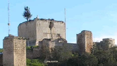
Photo
Where is located Castillo de Morón
Castillo de Morón — local attraction, which is located at 41530 Morón de la Frontera, Seville, Spain and belongs to the category — castle. Average visitor rating for this place — 4.1 (according to 151 rating, information from open sources and relevant for 2022).
Exact location — Castillo de Morón, marked on the map with a red marker.
You can get directions to Castillo de Morón on the map from your location.
What else is interesting in Morón de la Frontera? You can see all the sights if you go to the city page.
Coordinates
Castillo de Morón, Spain coordinates in decimal format: latitude — 37.12014628297453, longitude — -5.44899977515167. When converted to degrees, minutes, seconds Castillo de Morón has the following coordinates: 37°7′12.53 north latitude and -5°26′56.4 east longitude.
Nearby cities
The largest cities that are located nearby:
- Dos Hermanas — 45 km
- Jerez — 77 km
- Marbella — 85 km
- Cádiz — 99 km
- Málaga — 99 km
- Córdoba — 103 km
- Algeciras — 108 km
- Huelva — 132 km
- Tangier
 (Morocco) — 154 km
 - Jaén — 163 km
- Granada — 164 km
- Tetouan (Morocco) — 172 km
- Badajoz — 234 km
- Almería — 267 km
- Taounate (Morocco) — 295 km
- Nador (Morocco) — 314 km
- Kenitra (Morocco) — 334 km
- Taza (Morocco) — 347 km
- Meknes (Morocco) — 357 km
Distance to the capital
Distance to the capital (Madrid) is about — 397 km.