
 Aguadilla Pueblo
Naranjo
Cruces
Guanábano
Marías
Portillo
Camuy
Sabana Llana Norte
Aguadilla Pueblo
Aguadilla Pueblo
Naranjo
Cruces
Guanábano
Marías
Portillo
Camuy
Sabana Llana Norte
Playa Isla Verde on the map, Carolina, Puerto Rico
Photo
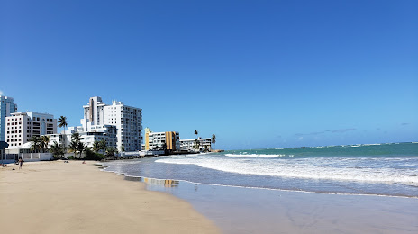
Where is located Playa Isla Verde
Playa Isla Verde — local attraction, which is located at no data and belongs to the category — -. Average visitor rating for this place — 4.7 (according to 66 ratings, information from open sources and relevant for 2022).
Exact location — Playa Isla Verde, marked on the map with a red marker.
You can get directions to Playa Isla Verde on the map from your location.
What else is interesting in Carolina? You can see all the sights if you go to the city page.
Coordinates
Playa Isla Verde, Puerto Rico coordinates in decimal format: latitude — 18.44051532847476, longitude — -66.01096052294398. When converted to degrees, minutes, seconds Playa Isla Verde has the following coordinates: 18°26′25.86 north latitude and -66°0′39.46 east longitude.
Nearby cities
The largest cities that are located nearby:
- Bayamón — 22 km
- Ponce — 80 km
- Punta Cana
 (Dominican Republic) — 258 km
 - La Romana (Dominican Republic) — 316 km
- San Pedro de Macoris (Dominican Republic) — 351 km
- Santo Domingo (Dominican Republic) — 419 km
- San Cristobal (Dominican Republic) — 435 km
- San Francisco de Macoris (Dominican Republic) — 459 km
- La Vega (Dominican Republic) — 486 km
- Santiago De Los Caballeros (Dominican Republic) — 509 km
- Puerto Plata (Dominican Republic) — 516 km
- Cap-Haitien
 (Haiti) — 667 km
 - Port-au-Prince (Haiti) — 669 km
- Carrefour (Haiti) — 677 km
- Léogâne (Haiti) — 699 km
- Setpoint
 (Venezuela) — 868 km
 - Catia La Mar (Venezuela) — 870 km
- Coro (Venezuela) — 871 km
- Guarenas (Venezuela) — 878 km
Distance to the capital
Distance to the capital (Saint John) is about — 10 km.