
 Maureville
Samoëns
Gréning
Toulouse
Volx
Goudet
Méhoncourt
Saint-Hymer
Pontcarré
Maureville
Samoëns
Gréning
Toulouse
Volx
Goudet
Méhoncourt
Saint-Hymer
Pontcarré
Commanderie de Sainte-Eulalie-de-Cernon on the map, Millau, France
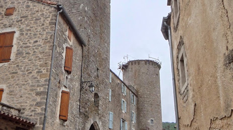
Photo
Where is located Commanderie de Sainte-Eulalie-de-Cernon
Commanderie de Sainte-Eulalie-de-Cernon — local attraction, which is located at 12230 Sainte-Eulalie-de-Cernon, France and belongs to the category — tourist attraction. Average visitor rating for this place — 4.0 (according to 2 ratings, information from open sources and relevant for 2022).
Exact location — Commanderie de Sainte-Eulalie-de-Cernon, marked on the map with a red marker.
You can get directions to Commanderie de Sainte-Eulalie-de-Cernon on the map from your location.
What else is interesting in Millau? You can see all the sights if you go to the city page.
Coordinates
Commanderie de Sainte-Eulalie-de-Cernon, France coordinates in decimal format: latitude — 43.95937751352963, longitude — 3.152893538635186. When converted to degrees, minutes, seconds Commanderie de Sainte-Eulalie-de-Cernon has the following coordinates: 43°57′33.76 north latitude and 3°9′10.42 east longitude.
Nearby cities
The largest cities that are located nearby:
- Montpellier — 84 km
- Nimes — 106 km
- Toulouse — 142 km
- Perpignan — 157 km
- Saint-Étienne — 180 km
- Clermont-Ferrand — 185 km
- Aix-en-Provence — 200 km
- Marseille — 205 km
- Lyon — 228 km
- Villeurbanne — 232 km
- Limoges — 237 km
- Grenoble — 239 km
- Toulon — 254 km
- Mataró
 (Spain) — 288 km
 - Sabadell (Spain) — 294 km
- Terrassa (Spain) — 294 km
- Bordeaux — 298 km
- Badalona (Spain) — 301 km
- Santa Coloma de Gramenet (Spain) — 302 km
Distance to the capital
Distance to the capital (Paris) is about — 548 km.