
 Maureville
Samoëns
Gréning
Toulouse
Volx
Goudet
Méhoncourt
Saint-Hymer
Pontcarré
Maureville
Samoëns
Gréning
Toulouse
Volx
Goudet
Méhoncourt
Saint-Hymer
Pontcarré
Église Saint-Louis on the map, Rochefort, France
Photo
Where is located Église Saint-Louis
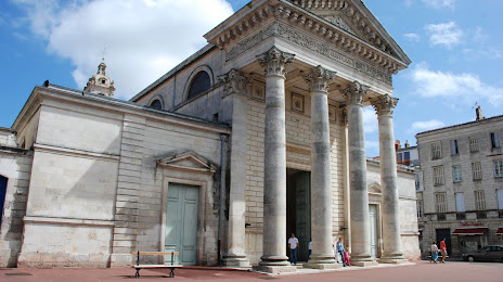
Église Saint-Louis — local attraction, which is located at Rue Audry de Puyravault, 17300 Rochefort, France and belongs to the category — catholic church. Average visitor rating for this place — 4.3 (according to 46 ratings, information from open sources and relevant for 2022).
Exact location — Église Saint-Louis, marked on the map with a red marker.
You can get directions to Église Saint-Louis on the map from your location.
What else is interesting in Rochefort? You can see all the sights if you go to the city page.
Coordinates
Église Saint-Louis, France coordinates in decimal format: latitude — 45.937233903154016, longitude — -0.9624479748772237. When converted to degrees, minutes, seconds Église Saint-Louis has the following coordinates: 45°56′14.04 north latitude and -0°57′44.81 east longitude.
Nearby cities
The largest cities that are located nearby:
- Bordeaux — 125 km
- Nantes — 149 km
- Limoges — 172 km
- Angers — 173 km
- Tours — 203 km
- Le Mans — 244 km
- Rennes — 247 km
- San Sebastián
 (Spain) — 301 km
 - Orléans — 304 km
- Clermont-Ferrand — 313 km
- Toulouse — 322 km
- Bilbao (Spain) — 336 km
- Pamplona (Spain) — 350 km
- Santander (Spain) — 356 km
- Caen — 361 km
- Vitoria-Gasteiz (Spain) — 368 km
- Brest — 375 km
- Boulogne-Billancourt — 397 km
- Le Havre — 401 km
Distance to the capital
Distance to the capital (Paris) is about — 409 km.