
 Maureville
Samoëns
Gréning
Toulouse
Volx
Goudet
Méhoncourt
Saint-Hymer
Pontcarré
Maureville
Samoëns
Gréning
Toulouse
Volx
Goudet
Méhoncourt
Saint-Hymer
Pontcarré
Chapelle des jésuites on the map, Chaumont, France
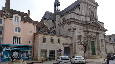
Photo
Where is located Chapelle des jésuites
Chapelle des jésuites — local attraction, which is located at Rue Victoire de la Marne, 52000 Chaumont, France and belongs to the category — chapel. Average visitor rating for this place — 3.7 (according to 3 ratings, information from open sources and relevant for 2022).
Exact location — Chapelle des jésuites, marked on the map with a red marker.
You can get directions to Chapelle des jésuites on the map from your location.
What else is interesting in Chaumont? You can see all the sights if you go to the city page.
Coordinates
Chapelle des jésuites, France coordinates in decimal format: latitude — 48.11259664433641, longitude — 5.141099325197566. When converted to degrees, minutes, seconds Chapelle des jésuites has the following coordinates: 48°6′45.35 north latitude and 5°8′27.96 east longitude.
Nearby cities
The largest cities that are located nearby:
- Dijon — 88 km
- Nancy — 100 km
- Besançon — 117 km
- Metz — 134 km
- Reims — 150 km
- Mulhouse — 168 km
- Saarbrücken
 (Germany) — 183 km
 - Basel
 (Switzerland) — 193 km
 - Strasbourg — 198 km
- Freiburg (Germany) — 200 km
- Lausanne (Switzerland) — 210 km
- Trier (Germany) — 210 km
- Bern (Switzerland) — 217 km
- Geneva (Switzerland) — 225 km
- Boulogne-Billancourt — 226 km
- Orléans — 241 km
- Karlsruhe (Germany) — 257 km
- Charleroi
 (Belgium) — 259 km
 - Villeurbanne — 260 km
Distance to the capital
Distance to the capital (Paris) is about — 222 km.