
 Maureville
Samoëns
Gréning
Toulouse
Volx
Goudet
Méhoncourt
Saint-Hymer
Pontcarré
Maureville
Samoëns
Gréning
Toulouse
Volx
Goudet
Méhoncourt
Saint-Hymer
Pontcarré
Église Saint-Blaise on the map, Vichy, France
Photo
Where is located Église Saint-Blaise
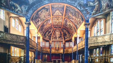
Église Saint-Blaise — local attraction, which is located at 1 Pl. d'Allier, 03200 Vichy, France and belongs to the category — catholic church. Average visitor rating for this place — 4.5 (according to 651 rating, information from open sources and relevant for 2022).
Exact location — Église Saint-Blaise, marked on the map with a red marker.
You can get directions to Église Saint-Blaise on the map from your location.
What else is interesting in Vichy? You can see all the sights if you go to the city page.
Coordinates
Église Saint-Blaise, France coordinates in decimal format: latitude — 46.12112931468087, longitude — 3.422124825128995. When converted to degrees, minutes, seconds Église Saint-Blaise has the following coordinates: 46°7′16.07 north latitude and 3°25′19.65 east longitude.
Nearby cities
The largest cities that are located nearby:
- Clermont-Ferrand — 47 km
- Saint-Étienne — 107 km
- Lyon — 116 km
- Villeurbanne — 120 km
- Limoges — 170 km
- Dijon — 179 km
- Grenoble — 207 km
- Geneva
 (Switzerland) — 208 km
 - Orléans — 226 km
- Besançon — 230 km
- Lausanne (Switzerland) — 248 km
- Tours — 248 km
- Nimes — 264 km
- Montpellier — 281 km
- Boulogne-Billancourt — 312 km
- Le Mans — 316 km
- Bern (Switzerland) — 316 km
- Toulouse — 321 km
- Aix-en-Provence — 330 km
Distance to the capital
Distance to the capital (Paris) is about — 315 km.