
 Maureville
Samoëns
Gréning
Toulouse
Volx
Goudet
Méhoncourt
Saint-Hymer
Pontcarré
Maureville
Samoëns
Gréning
Toulouse
Volx
Goudet
Méhoncourt
Saint-Hymer
Pontcarré
Château de La Poivrière on the map, Vichy, France
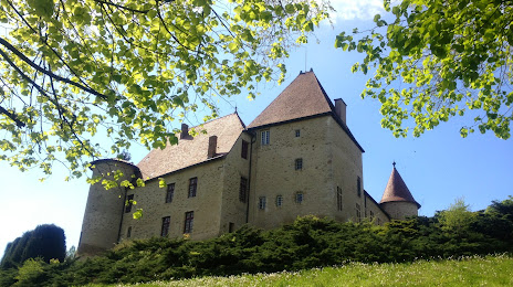
Photo
Where is located Château de La Poivrière
Château de La Poivrière — local attraction, which is located at Route de Saint-Yorre, Saint-Sylvestre-Pragoulin, 63310 Saint-Sylvestre-Pragoulin, France and belongs to the category — tourist attraction. Average visitor rating for this place — 3.5 (according to 6 ratings, information from open sources and relevant for 2022).
Exact location — Château de La Poivrière, marked on the map with a red marker.
You can get directions to Château de La Poivrière on the map from your location.
What else is interesting in Vichy? You can see all the sights if you go to the city page.
Coordinates
Château de La Poivrière, France coordinates in decimal format: latitude — 46.052902082808224, longitude — 3.4636471617287197. When converted to degrees, minutes, seconds Château de La Poivrière has the following coordinates: 46°3′10.45 north latitude and 3°27′49.13 east longitude.
Nearby cities
The largest cities that are located nearby:
- Clermont-Ferrand — 47 km
- Saint-Étienne — 107 km
- Lyon — 116 km
- Villeurbanne — 120 km
- Limoges — 170 km
- Dijon — 179 km
- Grenoble — 207 km
- Geneva
 (Switzerland) — 208 km
 - Orléans — 226 km
- Besançon — 230 km
- Lausanne (Switzerland) — 248 km
- Tours — 248 km
- Nimes — 264 km
- Montpellier — 281 km
- Boulogne-Billancourt — 312 km
- Le Mans — 316 km
- Bern (Switzerland) — 316 km
- Toulouse — 321 km
- Aix-en-Provence — 330 km
Distance to the capital
Distance to the capital (Paris) is about — 323 km.