
 Maureville
Samoëns
Gréning
Toulouse
Volx
Goudet
Méhoncourt
Saint-Hymer
Pontcarré
Maureville
Samoëns
Gréning
Toulouse
Volx
Goudet
Méhoncourt
Saint-Hymer
Pontcarré
Iglesia de San Esteban de la Ciudad on the map, Périgueux, France
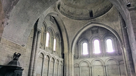
Photo
Where is located Iglesia de San Esteban de la Ciudad
Iglesia de San Esteban de la Ciudad — local attraction, which is located at 24000 Périgueux, France and belongs to the category — catholic church. Average visitor rating for this place — 4.3 (according to 51 rating, information from open sources and relevant for 2022).
Exact location — Iglesia de San Esteban de la Ciudad, marked on the map with a red marker.
You can get directions to Iglesia de San Esteban de la Ciudad on the map from your location.
What else is interesting in Périgueux? You can see all the sights if you go to the city page.
Coordinates
Iglesia de San Esteban de la Ciudad, France coordinates in decimal format: latitude — 45.181571248520235, longitude — 0.7153824250974342. When converted to degrees, minutes, seconds Iglesia de San Esteban de la Ciudad has the following coordinates: 45°10′53.66 north latitude and 0°42′55.38 east longitude.
Nearby cities
The largest cities that are located nearby:
- Limoges — 83 km
- Bordeaux — 109 km
- Toulouse — 184 km
- Clermont-Ferrand — 194 km
- Tours — 244 km
- Angers — 271 km
- Nantes — 282 km
- Saint-Étienne — 286 km
- San Sebastián
 (Spain) — 300 km
 - Montpellier — 307 km
- Orléans — 313 km
- Le Mans — 314 km
- Lyon — 324 km
- Pamplona (Spain) — 325 km
- Nimes — 326 km
- Perpignan — 328 km
- Villeurbanne — 328 km
- Bilbao (Spain) — 363 km
- Rennes — 369 km
Distance to the capital
Distance to the capital (Paris) is about — 427 km.