
 Maureville
Samoëns
Gréning
Toulouse
Volx
Goudet
Méhoncourt
Saint-Hymer
Pontcarré
Maureville
Samoëns
Gréning
Toulouse
Volx
Goudet
Méhoncourt
Saint-Hymer
Pontcarré
Les Halles de Narbonne on the map, Narbonne, France
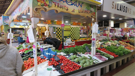
Photo
Where is located Les Halles de Narbonne
Les Halles de Narbonne — local attraction, which is located at 1 Cr Mirabeau, 11000 Narbonne, France and belongs to the category — fresh food market. Average visitor rating for this place — 4.4 (according to 11349 ratings, information from open sources and relevant for 2022).
Exact location — Les Halles de Narbonne, marked on the map with a red marker.
You can get directions to Les Halles de Narbonne on the map from your location.
What else is interesting in Narbonne? You can see all the sights if you go to the city page.
Coordinates
Les Halles de Narbonne, France coordinates in decimal format: latitude — 43.18122577389141, longitude — 3.0054251250319433. When converted to degrees, minutes, seconds Les Halles de Narbonne has the following coordinates: 43°10′52.41 north latitude and 3°0′19.53 east longitude.
Nearby cities
The largest cities that are located nearby:
- Perpignan — 55 km
- Montpellier — 84 km
- Nimes — 130 km
- Toulouse — 133 km
- Mataró
 (Spain) — 188 km
 - Marseille — 191 km
- Sabadell (Spain) — 196 km
- Terrassa (Spain) — 197 km
- Aix-en-Provence — 200 km
- Badalona (Spain) — 202 km
- Santa Coloma de Gramenet (Spain) — 203 km
- L'Hospitalet de Llobregat (Spain) — 214 km
- Toulon — 236 km
- Lleida (Spain) — 262 km
- Tarragona (Spain) — 271 km
- Saint-Étienne — 271 km
- Clermont-Ferrand — 287 km
- Grenoble — 307 km
- Lyon — 318 km
Distance to the capital
Distance to the capital (Paris) is about — 633 km.