
 Maureville
Samoëns
Gréning
Toulouse
Volx
Goudet
Méhoncourt
Saint-Hymer
Pontcarré
Maureville
Samoëns
Gréning
Toulouse
Volx
Goudet
Méhoncourt
Saint-Hymer
Pontcarré
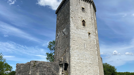
Château Moncade on the map, Orthez, France
Photo
Where is located Château Moncade
Château Moncade — local attraction, which is located at Rue Moncade, 64300 Orthez, France and belongs to the category — cultural landmark. Average visitor rating for this place — 4.2 (according to 194 ratings, information from open sources and relevant for 2022).
Exact location — Château Moncade, marked on the map with a red marker.
You can get directions to Château Moncade on the map from your location.
What else is interesting in Orthez? You can see all the sights if you go to the city page.
Coordinates
Château Moncade, France coordinates in decimal format: latitude — 43.49210235365523, longitude — -0.7699852749580554. When converted to degrees, minutes, seconds Château Moncade has the following coordinates: 43°29′31.57 north latitude and -0°46′11.95 east longitude.
Nearby cities
The largest cities that are located nearby:
- San Sebastián
 (Spain) — 99 km
 - Pamplona (Spain) — 103 km
- Bordeaux — 150 km
- Vitoria-Gasteiz (Spain) — 170 km
- Bilbao (Spain) — 176 km
- Logroño (Spain) — 177 km
- Toulouse — 178 km
- Zaragoza (Spain) — 204 km
- Lleida (Spain) — 237 km
- Santander (Spain) — 244 km
- Burgos (Spain) — 270 km
- Limoges — 303 km
- Perpignan — 311 km
- Tarragona (Spain) — 311 km
- Terrassa (Spain) — 313 km
- Sabadell (Spain) — 321 km
- Santa Coloma de Gramenet (Spain) — 335 km
- L'Hospitalet de Llobregat (Spain) — 335 km
- Badalona (Spain) — 337 km
Distance to the capital
Distance to the capital (Paris) is about — 643 km.