
 Maureville
Samoëns
Gréning
Toulouse
Volx
Goudet
Méhoncourt
Saint-Hymer
Pontcarré
Maureville
Samoëns
Gréning
Toulouse
Volx
Goudet
Méhoncourt
Saint-Hymer
Pontcarré
on the map, Enghien-les-Bains, France
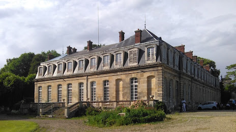
Photo
Where is located
— local attraction, which is located at 7 Rond-Point de la Victoire, 95400 Arnouville, France and belongs to the category — castle. Average visitor rating for this place — 4.4 (according to 5 ratings, information from open sources and relevant for 2022).
Exact location — , marked on the map with a red marker.
You can get directions to on the map from your location.
What else is interesting in Enghien-les-Bains? You can see all the sights if you go to the city page.
Coordinates
, France coordinates in decimal format: latitude — 48.97980359209429, longitude — 2.4186823252281076. When converted to degrees, minutes, seconds has the following coordinates: 48°58′47.29 north latitude and 2°25′7.26 east longitude.
Nearby cities
The largest cities that are located nearby:
- Boulogne-Billancourt — 15 km
- Rouen — 101 km
- Amiens — 102 km
- Orléans — 122 km
- Reims — 129 km
- Le Havre — 168 km
- Le Mans — 189 km
- Lille — 191 km
- Caen — 195 km
- Tours — 212 km
- Charleroi
 (Belgium) — 219 km
 - Eastbourne
 (United Kingdom) — 244 km
 - Namur (Belgium) — 245 km
- Brussels (Belgium) — 252 km
- Angers — 270 km
- Dijon — 274 km
- Metz — 281 km
- Nancy — 285 km
- Antwerp (Belgium) — 288 km
Distance to the capital
Distance to the capital (Paris) is about — 15 km.