
 Maureville
Samoëns
Gréning
Toulouse
Volx
Goudet
Méhoncourt
Saint-Hymer
Pontcarré
Maureville
Samoëns
Gréning
Toulouse
Volx
Goudet
Méhoncourt
Saint-Hymer
Pontcarré
Château d'Ardelay on the map, Les Herbiers, France
Photo
Where is located Château d'Ardelay
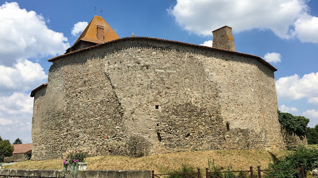
Château d'Ardelay — local attraction, which is located at Rue du Donjon, 85500 Les Herbiers, France and belongs to the category — tourist attraction. Average visitor rating for this place — 4.1 (according to 157 ratings, information from open sources and relevant for 2022).
Exact location — Château d'Ardelay, marked on the map with a red marker.
You can get directions to Château d'Ardelay on the map from your location.
What else is interesting in Les Herbiers? You can see all the sights if you go to the city page.
Coordinates
Château d'Ardelay, France coordinates in decimal format: latitude — 46.85233916154477, longitude — -1.0053383748460891. When converted to degrees, minutes, seconds Château d'Ardelay has the following coordinates: 46°51′8.42 north latitude and -1°0′19.22 east longitude.
Nearby cities
The largest cities that are located nearby:
- Nantes — 56 km
- Angers — 75 km
- Tours — 140 km
- Rennes — 146 km
- Le Mans — 154 km
- Limoges — 209 km
- Bordeaux — 227 km
- Orléans — 245 km
- Caen — 260 km
- Le Havre — 301 km
- Brest — 305 km
- Boulogne-Billancourt — 322 km
- Rouen — 323 km
- Clermont-Ferrand — 338 km
- San Sebastián
 (Spain) — 400 km
 - Amiens — 409 km
- Toulouse — 411 km
- Bilbao (Spain) — 428 km
- Bournemouth
 (United Kingdom) — 430 km
Distance to the capital
Distance to the capital (Paris) is about — 335 km.