
 Maureville
Samoëns
Gréning
Toulouse
Volx
Goudet
Méhoncourt
Saint-Hymer
Pontcarré
Maureville
Samoëns
Gréning
Toulouse
Volx
Goudet
Méhoncourt
Saint-Hymer
Pontcarré
Castle Park on the map, Mâcon, France
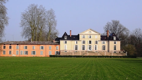
Photo
Where is located Castle Park
Castle Park — local attraction, which is located at 26 Grande Rue, 01290 Pont-de-Veyle, France and belongs to the category — park. Average visitor rating for this place — 4.3 (according to 323 ratings, information from open sources and relevant for 2022).
Exact location — Castle Park, marked on the map with a red marker.
You can get directions to Castle Park on the map from your location.
What else is interesting in Mâcon? You can see all the sights if you go to the city page.
Coordinates
Castle Park, France coordinates in decimal format: latitude — 46.266231602924876, longitude — 4.881721925133905. When converted to degrees, minutes, seconds Castle Park has the following coordinates: 46°15′58.43 north latitude and 4°52′54.2 east longitude.
Nearby cities
The largest cities that are located nearby:
- Villeurbanne — 59 km
- Lyon — 60 km
- Geneva
 (Switzerland) — 101 km
 - Saint-Étienne — 102 km
- Dijon — 113 km
- Besançon — 137 km
- Lausanne (Switzerland) — 139 km
- Grenoble — 142 km
- Clermont-Ferrand — 147 km
- Bern (Switzerland) — 210 km
- Mulhouse — 245 km
- Basel (Switzerland) — 249 km
- Turin
 (Italy) — 262 km
 - Nimes — 276 km
- Orléans — 279 km
- Limoges — 280 km
- Nancy — 282 km
- Freiburg
 (Germany) — 291 km
 - Zurich (Switzerland) — 302 km
Distance to the capital
Distance to the capital (Paris) is about — 345 km.