
 Maureville
Samoëns
Gréning
Toulouse
Volx
Goudet
Méhoncourt
Saint-Hymer
Pontcarré
Maureville
Samoëns
Gréning
Toulouse
Volx
Goudet
Méhoncourt
Saint-Hymer
Pontcarré
Park Alexis Gruss (Le Parc Alexis Gruss) on the map, Orange, France
Photo
Where is located Park Alexis Gruss (Le Parc Alexis Gruss)
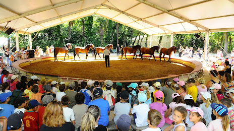
Park Alexis Gruss (Le Parc Alexis Gruss) — local attraction, which is located at N7, 84420 Piolenc, France and belongs to the category — amusement center. Average visitor rating for this place — 4.5 (according to 312 ratings, information from open sources and relevant for 2022).
Exact location — Park Alexis Gruss (Le Parc Alexis Gruss), marked on the map with a red marker.
You can get directions to Park Alexis Gruss (Le Parc Alexis Gruss) on the map from your location.
What else is interesting in Orange? You can see all the sights if you go to the city page.
Coordinates
Park Alexis Gruss (Le Parc Alexis Gruss), France coordinates in decimal format: latitude — 44.16362014547948, longitude — 4.771220725063784. When converted to degrees, minutes, seconds Park Alexis Gruss (Le Parc Alexis Gruss) has the following coordinates: 44°9′49.03 north latitude and 4°46′16.39 east longitude.
Nearby cities
The largest cities that are located nearby:
- Nimes — 49 km
- Aix-en-Provence — 85 km
- Montpellier — 95 km
- Marseille — 103 km
- Grenoble — 136 km
- Toulon — 144 km
- Saint-Étienne — 148 km
- Lyon — 180 km
- Villeurbanne — 181 km
- Nice — 202 km
- Perpignan — 223 km
- Clermont-Ferrand — 225 km
- Turin
 (Italy) — 247 km
 - Geneva
 (Switzerland) — 250 km
 - Toulouse — 276 km
- Lausanne (Switzerland) — 298 km
- Genoa (Italy) — 328 km
- Novara (Italy) — 329 km
- Limoges — 331 km
Distance to the capital
Distance to the capital (Paris) is about — 554 km.