
 Maureville
Samoëns
Gréning
Toulouse
Volx
Goudet
Méhoncourt
Saint-Hymer
Pontcarré
Maureville
Samoëns
Gréning
Toulouse
Volx
Goudet
Méhoncourt
Saint-Hymer
Pontcarré
Château d'Hauterive on the map, Issoire, France
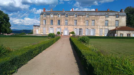
Photo
Where is located Château d'Hauterive
Château d'Hauterive — local attraction, which is located at Rte d'Hauterive, 63500 Issoire, France and belongs to the category — garden. Average visitor rating for this place — 4.1 (according to 54 ratings, information from open sources and relevant for 2022).
Exact location — Château d'Hauterive, marked on the map with a red marker.
You can get directions to Château d'Hauterive on the map from your location.
What else is interesting in Issoire? You can see all the sights if you go to the city page.
Coordinates
Château d'Hauterive, France coordinates in decimal format: latitude — 45.534973160405684, longitude — 3.233409825109255. When converted to degrees, minutes, seconds Château d'Hauterive has the following coordinates: 45°32′5.9 north latitude and 3°14′0.28 east longitude.
Nearby cities
The largest cities that are located nearby:
- Clermont-Ferrand — 29 km
- Saint-Étienne — 89 km
- Lyon — 125 km
- Villeurbanne — 129 km
- Limoges — 156 km
- Grenoble — 197 km
- Nimes — 208 km
- Montpellier — 219 km
- Geneva
 (Switzerland) — 233 km
 - Dijon — 238 km
- Toulouse — 258 km
- Orléans — 279 km
- Lausanne (Switzerland) — 279 km
- Besançon — 280 km
- Tours — 281 km
- Aix-en-Provence — 284 km
- Marseille — 301 km
- Bordeaux — 310 km
- Perpignan — 317 km
Distance to the capital
Distance to the capital (Paris) is about — 375 km.