
 Maureville
Samoëns
Gréning
Toulouse
Volx
Goudet
Méhoncourt
Saint-Hymer
Pontcarré
Maureville
Samoëns
Gréning
Toulouse
Volx
Goudet
Méhoncourt
Saint-Hymer
Pontcarré
Chateau de Villeneuve-Lembron on the map, Issoire, France
Photo
Where is located Chateau de Villeneuve-Lembron
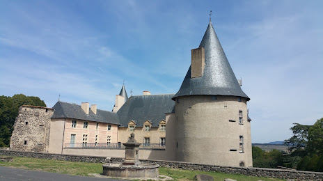
Chateau de Villeneuve-Lembron — local attraction, which is located at Château de Villeneuve-Lembron, 63340 Villeneuve-Lembron, France and belongs to the category — monument. Average visitor rating for this place — 4.5 (according to 280 ratings, information from open sources and relevant for 2022).
Exact location — Chateau de Villeneuve-Lembron, marked on the map with a red marker.
You can get directions to Chateau de Villeneuve-Lembron on the map from your location.
What else is interesting in Issoire? You can see all the sights if you go to the city page.
Coordinates
Chateau de Villeneuve-Lembron, France coordinates in decimal format: latitude — 45.47797112614209, longitude — 3.185837625107319. When converted to degrees, minutes, seconds Chateau de Villeneuve-Lembron has the following coordinates: 45°28′40.7 north latitude and 3°11′9.02 east longitude.
Nearby cities
The largest cities that are located nearby:
- Clermont-Ferrand — 29 km
- Saint-Étienne — 89 km
- Lyon — 125 km
- Villeurbanne — 129 km
- Limoges — 156 km
- Grenoble — 197 km
- Nimes — 208 km
- Montpellier — 219 km
- Geneva
 (Switzerland) — 233 km
 - Dijon — 238 km
- Toulouse — 258 km
- Orléans — 279 km
- Lausanne (Switzerland) — 279 km
- Besançon — 280 km
- Tours — 281 km
- Aix-en-Provence — 284 km
- Marseille — 301 km
- Bordeaux — 310 km
- Perpignan — 317 km
Distance to the capital
Distance to the capital (Paris) is about — 381 km.