
 Maureville
Samoëns
Gréning
Toulouse
Volx
Goudet
Méhoncourt
Saint-Hymer
Pontcarré
Maureville
Samoëns
Gréning
Toulouse
Volx
Goudet
Méhoncourt
Saint-Hymer
Pontcarré
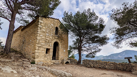
Chapelle Saint-Christophe on the map, Carpentras, France
Photo
Where is located Chapelle Saint-Christophe
Chapelle Saint-Christophe — local attraction, which is located at 1 Route de Beaumes, 84190 Lafare, France and belongs to the category — chapel. Average visitor rating for this place — 4.4 (according to 59 ratings, information from open sources and relevant for 2022).
Exact location — Chapelle Saint-Christophe, marked on the map with a red marker.
You can get directions to Chapelle Saint-Christophe on the map from your location.
What else is interesting in Carpentras? You can see all the sights if you go to the city page.
Coordinates
Chapelle Saint-Christophe, France coordinates in decimal format: latitude — 44.157113741660154, longitude — 5.048667025063584. When converted to degrees, minutes, seconds Chapelle Saint-Christophe has the following coordinates: 44°9′25.61 north latitude and 5°2′55.2 east longitude.
Nearby cities
The largest cities that are located nearby:
- Nimes — 60 km
- Aix-en-Provence — 66 km
- Marseille — 88 km
- Montpellier — 106 km
- Toulon — 125 km
- Grenoble — 136 km
- Saint-Étienne — 161 km
- Nice — 181 km
- Lyon — 190 km
- Villeurbanne — 190 km
- Perpignan — 231 km
- Turin
 (Italy) — 235 km
 - Clermont-Ferrand — 243 km
- Geneva
 (Switzerland) — 251 km
 - Toulouse — 293 km
- Lausanne (Switzerland) — 298 km
- Genoa (Italy) — 310 km
- Novara (Italy) — 317 km
- Limoges — 352 km
Distance to the capital
Distance to the capital (Paris) is about — 562 km.