
 Maureville
Samoëns
Gréning
Toulouse
Volx
Goudet
Méhoncourt
Saint-Hymer
Pontcarré
Maureville
Samoëns
Gréning
Toulouse
Volx
Goudet
Méhoncourt
Saint-Hymer
Pontcarré
Château de Montigny on the map, Châteaudun, France
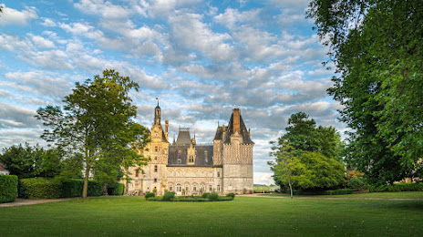
Photo
Where is located Château de Montigny
Château de Montigny — local attraction, which is located at 28220 Cloyes-les-Trois-Rivières, France and belongs to the category — castle. Average visitor rating for this place — 4.4 (according to 345 ratings, information from open sources and relevant for 2022).
Exact location — Château de Montigny, marked on the map with a red marker.
You can get directions to Château de Montigny on the map from your location.
What else is interesting in Châteaudun? You can see all the sights if you go to the city page.
Coordinates
Château de Montigny, France coordinates in decimal format: latitude — 48.070705818063196, longitude — 1.3229837251960872. When converted to degrees, minutes, seconds Château de Montigny has the following coordinates: 48°4′14.54 north latitude and 1°19′22.74 east longitude.
Nearby cities
The largest cities that are located nearby:
- Orléans — 47 km
- Le Mans — 84 km
- Tours — 89 km
- Boulogne-Billancourt — 108 km
- Rouen — 153 km
- Angers — 156 km
- Caen — 174 km
- Le Havre — 180 km
- Amiens — 213 km
- Rennes — 222 km
- Reims — 235 km
- Nantes — 236 km
- Limoges — 247 km
- Clermont-Ferrand — 288 km
- Dijon — 290 km
- Eastbourne
 (United Kingdom) — 307 km
 - Lille — 308 km
- Charleroi
 (Belgium) — 339 km
 - Portsmouth (United Kingdom) — 348 km
Distance to the capital
Distance to the capital (Paris) is about — 116 km.