
 Maureville
Samoëns
Gréning
Toulouse
Volx
Goudet
Méhoncourt
Saint-Hymer
Pontcarré
Maureville
Samoëns
Gréning
Toulouse
Volx
Goudet
Méhoncourt
Saint-Hymer
Pontcarré
Regional area of Butte Pinson on the map, Stains, France
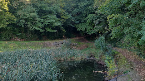
Photo
Where is located Regional area of Butte Pinson
Regional area of Butte Pinson — local attraction, which is located at 48-54 Rue de Pierrefitte, 95360 Montmagny, France and belongs to the category — state park. Average visitor rating for this place — 4.2 (according to 183 ratings, information from open sources and relevant for 2022).
Exact location — Regional area of Butte Pinson, marked on the map with a red marker.
You can get directions to Regional area of Butte Pinson on the map from your location.
What else is interesting in Stains? You can see all the sights if you go to the city page.
Coordinates
Regional area of Butte Pinson, France coordinates in decimal format: latitude — 48.96930993542252, longitude — 2.3531382252277124. When converted to degrees, minutes, seconds Regional area of Butte Pinson has the following coordinates: 48°58′9.52 north latitude and 2°21′11.3 east longitude.
Nearby cities
The largest cities that are located nearby:
- Boulogne-Billancourt — 17 km
- Amiens — 104 km
- Rouen — 107 km
- Orléans — 122 km
- Reims — 123 km
- Le Havre — 174 km
- Lille — 191 km
- Le Mans — 193 km
- Caen — 201 km
- Tours — 214 km
- Charleroi
 (Belgium) — 217 km
 - Namur (Belgium) — 242 km
- Eastbourne
 (United Kingdom) — 248 km
 - Brussels (Belgium) — 250 km
- Dijon — 269 km
- Angers — 274 km
- Metz — 275 km
- Nancy — 279 km
- Antwerp (Belgium) — 287 km
Distance to the capital
Distance to the capital (Paris) is about — 13 km.