
 Maureville
Samoëns
Gréning
Toulouse
Volx
Goudet
Méhoncourt
Saint-Hymer
Pontcarré
Maureville
Samoëns
Gréning
Toulouse
Volx
Goudet
Méhoncourt
Saint-Hymer
Pontcarré
Château d'Alba on the map, Montélimar, France
Photo
Where is located Château d'Alba
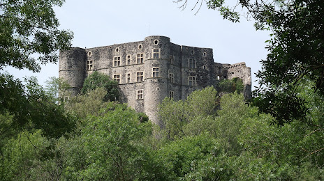
Château d'Alba — local attraction, which is located at Château d'Alba, 07400 Alba-la-Romaine, France and belongs to the category — castle. Average visitor rating for this place — 3.7 (according to 323 ratings, information from open sources and relevant for 2022).
Exact location — Château d'Alba, marked on the map with a red marker.
You can get directions to Château d'Alba on the map from your location.
What else is interesting in Montélimar? You can see all the sights if you go to the city page.
Coordinates
Château d'Alba, France coordinates in decimal format: latitude — 44.55517217615084, longitude — 4.599378275076649. When converted to degrees, minutes, seconds Château d'Alba has the following coordinates: 44°33′18.62 north latitude and 4°35′57.76 east longitude.
Nearby cities
The largest cities that are located nearby:
- Nimes — 85 km
- Saint-Étienne — 102 km
- Grenoble — 103 km
- Montpellier — 126 km
- Aix-en-Provence — 127 km
- Lyon — 134 km
- Villeurbanne — 135 km
- Marseille — 148 km
- Toulon — 185 km
- Clermont-Ferrand — 186 km
- Geneva
 (Switzerland) — 210 km
 - Nice — 222 km
- Turin
 (Italy) — 236 km
 - Perpignan — 256 km
- Lausanne (Switzerland) — 260 km
- Toulouse — 285 km
- Limoges — 304 km
- Dijon — 306 km
- Besançon — 311 km
Distance to the capital
Distance to the capital (Paris) is about — 508 km.