
 Maureville
Samoëns
Gréning
Toulouse
Volx
Goudet
Méhoncourt
Saint-Hymer
Pontcarré
Maureville
Samoëns
Gréning
Toulouse
Volx
Goudet
Méhoncourt
Saint-Hymer
Pontcarré
Site Le Corbusier on the map, Firminy, France
Photo
Where is located Site Le Corbusier
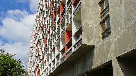
Site Le Corbusier — local attraction, which is located at Maison de la culture, Bd Périph. du Stade, 42700 Firminy, France and belongs to the category — cultural center. Average visitor rating for this place — 4.2 (according to 287 ratings, information from open sources and relevant for 2022).
Exact location — Site Le Corbusier, marked on the map with a red marker.
You can get directions to Site Le Corbusier on the map from your location.
What else is interesting in Firminy? You can see all the sights if you go to the city page.
Coordinates
Site Le Corbusier, France coordinates in decimal format: latitude — 45.382940069094325, longitude — 4.28683062510416. When converted to degrees, minutes, seconds Site Le Corbusier has the following coordinates: 45°22′58.58 north latitude and 4°17′12.59 east longitude.
Nearby cities
The largest cities that are located nearby:
- Saint-Étienne — 10 km
- Lyon — 59 km
- Villeurbanne — 63 km
- Clermont-Ferrand — 102 km
- Grenoble — 114 km
- Geneva
 (Switzerland) — 168 km
 - Nimes — 172 km
- Montpellier — 199 km
- Lausanne (Switzerland) — 218 km
- Dijon — 221 km
- Aix-en-Provence — 225 km
- Limoges — 238 km
- Besançon — 243 km
- Marseille — 247 km
- Turin
 (Italy) — 268 km
 - Toulon — 283 km
- Bern (Switzerland) — 294 km
- Toulouse — 301 km
- Nice — 301 km
Distance to the capital
Distance to the capital (Paris) is about — 413 km.