
 Maureville
Samoëns
Gréning
Toulouse
Volx
Goudet
Méhoncourt
Saint-Hymer
Pontcarré
Maureville
Samoëns
Gréning
Toulouse
Volx
Goudet
Méhoncourt
Saint-Hymer
Pontcarré
Château de La Branchoire on the map, Saint-Avertin, France
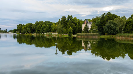
Photo
Where is located Château de La Branchoire
Château de La Branchoire — local attraction, which is located at no data and belongs to the category — -. Average visitor rating for this place — 4.5 (according to 125 ratings, information from open sources and relevant for 2022).
Exact location — Château de La Branchoire, marked on the map with a red marker.
You can get directions to Château de La Branchoire on the map from your location.
What else is interesting in Saint-Avertin? You can see all the sights if you go to the city page.
Coordinates
Château de La Branchoire, France coordinates in decimal format: latitude — 47.35260704912426, longitude — 0.6393861966993465. When converted to degrees, minutes, seconds Château de La Branchoire has the following coordinates: 47°21′9.39 north latitude and 0°38′21.79 east longitude.
Nearby cities
The largest cities that are located nearby:
- Tours — 4 km
- Le Mans — 81 km
- Angers — 97 km
- Orléans — 106 km
- Nantes — 172 km
- Limoges — 175 km
- Rennes — 196 km
- Boulogne-Billancourt — 196 km
- Caen — 216 km
- Rouen — 231 km
- Le Havre — 239 km
- Clermont-Ferrand — 253 km
- Bordeaux — 298 km
- Amiens — 301 km
- Reims — 317 km
- Dijon — 323 km
- Saint-Étienne — 355 km
- Lyon — 363 km
- Villeurbanne — 366 km
Distance to the capital
Distance to the capital (Paris) is about — 210 km.