
 Maureville
Samoëns
Gréning
Toulouse
Volx
Goudet
Méhoncourt
Saint-Hymer
Pontcarré
Maureville
Samoëns
Gréning
Toulouse
Volx
Goudet
Méhoncourt
Saint-Hymer
Pontcarré
Château de Pennesuyt on the map, Bourg-en-Bresse, France
Photo
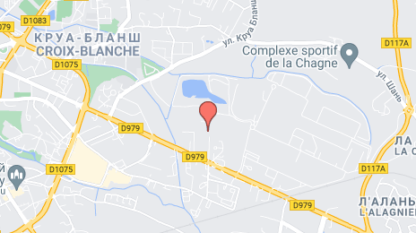
Where is located Château de Pennesuyt
Château de Pennesuyt — local attraction, which is located at Rue Marcel Duchamp, 01000 Bourg-en-Bresse, France and belongs to the category — castle. Average visitor rating for this place — 3.0 (according to 3 ratings, information from open sources and relevant for 2022).
Exact location — Château de Pennesuyt, marked on the map with a red marker.
You can get directions to Château de Pennesuyt on the map from your location.
What else is interesting in Bourg-en-Bresse? You can see all the sights if you go to the city page.
Coordinates
Château de Pennesuyt, France coordinates in decimal format: latitude — 46.20190006377515, longitude — 5.254329425131756. When converted to degrees, minutes, seconds Château de Pennesuyt has the following coordinates: 46°12′6.84 north latitude and 5°15′15.59 east longitude.
Nearby cities
The largest cities that are located nearby:
- Villeurbanne — 54 km
- Lyon — 57 km
- Geneva
 (Switzerland) — 70 km
 - Saint-Étienne — 107 km
- Lausanne (Switzerland) — 113 km
- Grenoble — 119 km
- Dijon — 124 km
- Besançon — 129 km
- Clermont-Ferrand — 172 km
- Bern (Switzerland) — 187 km
- Turin
 (Italy) — 230 km
 - Mulhouse — 232 km
- Basel (Switzerland) — 232 km
- Nimes — 271 km
- Novara (Italy) — 276 km
- Freiburg
 (Germany) — 277 km
 - Zurich (Switzerland) — 280 km
- Nancy — 284 km
- Aix-en-Provence — 296 km
Distance to the capital
Distance to the capital (Paris) is about — 367 km.