
 Maureville
Samoëns
Gréning
Toulouse
Volx
Goudet
Méhoncourt
Saint-Hymer
Pontcarré
Maureville
Samoëns
Gréning
Toulouse
Volx
Goudet
Méhoncourt
Saint-Hymer
Pontcarré
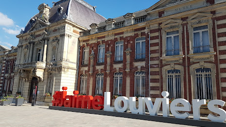
Museum of Louviers on the map, Louviers, France
Photo
Where is located Museum of Louviers
Museum of Louviers — local attraction, which is located at Pl. Ernest Thorel CS 10621, 27400 Louviers, France and belongs to the category — museum. Average visitor rating for this place — 4.1 (according to 63 ratings, information from open sources and relevant for 2022).
Exact location — Museum of Louviers, marked on the map with a red marker.
You can get directions to Museum of Louviers on the map from your location.
What else is interesting in Louviers? You can see all the sights if you go to the city page.
Coordinates
Museum of Louviers, France coordinates in decimal format: latitude — 49.22027079787353, longitude — 1.153416777120326. When converted to degrees, minutes, seconds Museum of Louviers has the following coordinates: 49°13′12.97 north latitude and 1°9′12.3 east longitude.
Nearby cities
The largest cities that are located nearby:
- Rouen — 26 km
- Le Havre — 82 km
- Boulogne-Billancourt — 88 km
- Amiens — 110 km
- Caen — 111 km
- Le Mans — 152 km
- Orléans — 155 km
- Eastbourne
 (United Kingdom) — 182 km
 - Tours — 205 km
- Lille — 205 km
- Reims — 207 km
- Crawley (United Kingdom) — 230 km
- Angers — 232 km
- Portsmouth (United Kingdom) — 237 km
- Rennes — 243 km
- Gillingham (United Kingdom) — 244 km
- Sutton (United Kingdom) — 255 km
- Southampton (United Kingdom) — 259 km
- Southend-on-Sea (United Kingdom) — 260 km
Distance to the capital
Distance to the capital (Paris) is about — 96 km.