
 Maureville
Samoëns
Gréning
Toulouse
Volx
Goudet
Méhoncourt
Saint-Hymer
Pontcarré
Maureville
Samoëns
Gréning
Toulouse
Volx
Goudet
Méhoncourt
Saint-Hymer
Pontcarré
Chapelle Saint-Jacques on the map, Vendôme, France
Photo
Where is located Chapelle Saint-Jacques
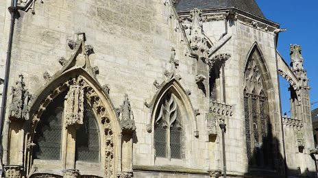
Chapelle Saint-Jacques — local attraction, which is located at 56 Rue du Change, 41100 Vendôme, France and belongs to the category — chapel. Average visitor rating for this place — 4.4 (according to 45 ratings, information from open sources and relevant for 2022).
Exact location — Chapelle Saint-Jacques, marked on the map with a red marker.
You can get directions to Chapelle Saint-Jacques on the map from your location.
What else is interesting in Vendôme? You can see all the sights if you go to the city page.
Coordinates
Chapelle Saint-Jacques, France coordinates in decimal format: latitude — 47.793536244663144, longitude — 1.0675435251864336. When converted to degrees, minutes, seconds Chapelle Saint-Jacques has the following coordinates: 47°47′36.73 north latitude and 1°4′3.16 east longitude.
Nearby cities
The largest cities that are located nearby:
- Tours — 52 km
- Orléans — 64 km
- Le Mans — 68 km
- Angers — 127 km
- Boulogne-Billancourt — 144 km
- Rouen — 183 km
- Caen — 185 km
- Le Havre — 200 km
- Rennes — 206 km
- Nantes — 207 km
- Limoges — 217 km
- Amiens — 248 km
- Reims — 268 km
- Clermont-Ferrand — 272 km
- Dijon — 303 km
- Eastbourne
 (United Kingdom) — 333 km
 - Lille — 343 km
- Bordeaux — 351 km
- Saint-Étienne — 366 km
Distance to the capital
Distance to the capital (Paris) is about — 152 km.