
 Maureville
Samoëns
Gréning
Toulouse
Volx
Goudet
Méhoncourt
Saint-Hymer
Pontcarré
Maureville
Samoëns
Gréning
Toulouse
Volx
Goudet
Méhoncourt
Saint-Hymer
Pontcarré
Plan d'Eau de Villiers-sur-Loir on the map, Vendôme, France
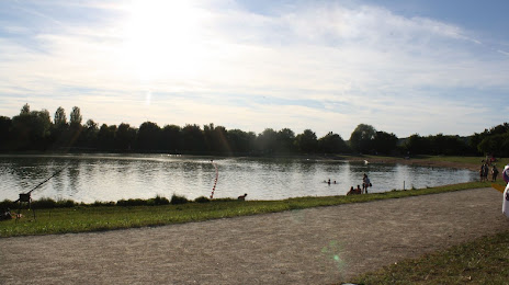
Photo
Where is located Plan d'Eau de Villiers-sur-Loir
Plan d'Eau de Villiers-sur-Loir — local attraction, which is located at no data and belongs to the category — -. Average visitor rating for this place — 4.2 (according to 69 ratings, information from open sources and relevant for 2022).
Exact location — Plan d'Eau de Villiers-sur-Loir, marked on the map with a red marker.
You can get directions to Plan d'Eau de Villiers-sur-Loir on the map from your location.
What else is interesting in Vendôme? You can see all the sights if you go to the city page.
Coordinates
Plan d'Eau de Villiers-sur-Loir, France coordinates in decimal format: latitude — 47.79825950363927, longitude — 0.9909901967612251. When converted to degrees, minutes, seconds Plan d'Eau de Villiers-sur-Loir has the following coordinates: 47°47′53.73 north latitude and 0°59′27.56 east longitude.
Nearby cities
The largest cities that are located nearby:
- Tours — 52 km
- Orléans — 64 km
- Le Mans — 68 km
- Angers — 127 km
- Boulogne-Billancourt — 144 km
- Rouen — 183 km
- Caen — 185 km
- Le Havre — 200 km
- Rennes — 206 km
- Nantes — 207 km
- Limoges — 217 km
- Amiens — 248 km
- Reims — 268 km
- Clermont-Ferrand — 272 km
- Dijon — 303 km
- Eastbourne
 (United Kingdom) — 333 km
 - Lille — 343 km
- Bordeaux — 351 km
- Saint-Étienne — 366 km
Distance to the capital
Distance to the capital (Paris) is about — 155 km.