
 Maureville
Samoëns
Gréning
Toulouse
Volx
Goudet
Méhoncourt
Saint-Hymer
Pontcarré
Maureville
Samoëns
Gréning
Toulouse
Volx
Goudet
Méhoncourt
Saint-Hymer
Pontcarré
Château-Gaillard on the map, Amboise, France
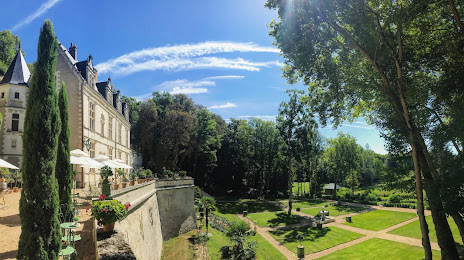
Photo
Where is located Château-Gaillard
Château-Gaillard — local attraction, which is located at 29 All. du Pont Moulin, 37400 Amboise, France and belongs to the category — castle. Average visitor rating for this place — 4.4 (according to 876 ratings, information from open sources and relevant for 2022).
Exact location — Château-Gaillard, marked on the map with a red marker.
You can get directions to Château-Gaillard on the map from your location.
What else is interesting in Amboise? You can see all the sights if you go to the city page.
Coordinates
Château-Gaillard, France coordinates in decimal format: latitude — 47.41040050622363, longitude — 0.9992948251731325. When converted to degrees, minutes, seconds Château-Gaillard has the following coordinates: 47°24′37.44 north latitude and 0°59′57.46 east longitude.
Nearby cities
The largest cities that are located nearby:
- Tours — 23 km
- Orléans — 87 km
- Le Mans — 88 km
- Angers — 116 km
- Limoges — 176 km
- Boulogne-Billancourt — 182 km
- Nantes — 192 km
- Rennes — 211 km
- Caen — 219 km
- Rouen — 225 km
- Le Havre — 239 km
- Clermont-Ferrand — 243 km
- Amiens — 290 km
- Reims — 300 km
- Dijon — 304 km
- Bordeaux — 310 km
- Saint-Étienne — 342 km
- Lyon — 349 km
- Villeurbanne — 352 km
Distance to the capital
Distance to the capital (Paris) is about — 190 km.